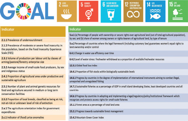
Perspectives from a Custodian Agency for
Agriculture, Forestry and Fisheries
Food and agriculture lie at the heart of the
2030 Agenda, with closely related development
outcomes that range from ending poverty and
hunger to maintaining and protecting the natural
resource base, and responding to climate
vulnerability and change. As a result, FAO was
chosen as the Custodian Agency of 21 SDG
indicators, with responsibilities for the
methodological development, the provision of
technical assistance and the collection and
dissemination of data for monitoring progress
towards a number of targets under Goal 2 ‘Zero
hunger’, Goal 5 ‘Gender equality’, Goal 6 ‘Clean
water and sanitation’, Goal 12 ‘Responsible
consumption’, Goal 14 ‘Life below water’ and
Goal 15 ‘Life on land.’ Data collected from
countries and new sources will allow monitoring
annual progress at a sub-regional, regional and
global level and will provide the evidence base
for the planned follow-up and review processes
in the context of the SDG High Level Political
Forum.
5.1 Tracking progress towards sustainable
development
Earth observations (EO) can provide a
significant contribution to the measurement of
many of the SDG indicators under FAO
custodianship. In particular, remote-sensing
images and georeferenced data can support the
design and development of more efficient and
accurate sampling frames in the preparation of
integrated agricultural surveys used for
monitoring SDG indicators. Secondly, area changes
in natural vegetation assessed from satellite
imagery directly inform the measures of specific
indicators, such as the Green Mountain Index.
Thirdly, EO stratified by land cover information
are useful auxiliary variables to enhance data
coherence and accuracy. For instance, satellite
imagery may complement ground observations for
computing critical sub-components of more complex
indicators, such as the measurement of the area
under sustainable and productive agriculture.
Finally, EO are key data for spatial
disaggregation, including for the distinction of
rural and urban areas required for the computation
of several SDG indicators.
Accordingly, FAO’s support to
countries, in the context of the SDG indicators,
increasingly includes capacity development
activities based on geospatial tools. This article
provides examples of the applications mentioned
above, as implemented by FAO, including with
support of the Global Strategy to Improve
Agriculture and Rural Statistics, demonstrating
the specific role EO can play in helping countries
meet the monitoring challenges ahead.
5.2 Farm-based surveys and the use of
geospatial information
Progress towards achieving Target 2.3
and Target 2.4 of Goal 2 is measured by three
global indicators that are meant to be informed by
agricultural surveys whose statistical unit is the
farm. Target 2.3, in particular, focuses on the
economic performance of small-scale food
producers, measured by their income and
productivity:
- indicator 2.3.1: volume of production per
labour unit by classes of farming/pastoral/
forestry enterprise size;
- indicator 2.3.2: average income of
small-scale food producers, by sex and
indigenous status.
Target 2.4
focuses on the sustainable increase of
agricultural productivity:
-
indicator 2.4.1: proportion of agricultural area
under productive and sustainable agriculture,
which entails maintaining agriculture’s
ecosystems function, by improving land and soil
quality and strengthening its capacity for
adaptation to climate change, including improved
resilience to extreme events and disasters.
Monitoring this target involves
measuring the economic, social and environmental
dimensions of agricultural sustainability with
appropriate sub-indicators.
The
official global indicators selected to measure
progress against targets 2.3 and 2.4 require a
common data collection framework, able to gather
timely and relevant environmental, economic and
social information at the farm level, with the
possibility of capturing disparities between
small- and large-scale food producers.
In order to better meet these
requirements and more generally the need to
improve the quality, consistency and timeliness
of national and sub-national agricultural data,
FAO has recently proposed a new approach to
agricultural surveys, the Agricultural
Integrated Surveys (AGRIS), which aims to gather
information on both the core activities and the
key characteristics of the farm, in particular
those that will be needed for monitoring of SDG
indicators 2.3.1, 2.3.2 and 2.4.1.
EO data, in particular satellite
imagery and ortho-rectified aerial photographs,
together with geo-referenced information are
essential tools in designing a consistent,
efficient and well-integrated sampling frame for
AGRIS in order to enable sampling and reporting
with equal efficiency at farm, household and
landscape scales, with the ability to link
information across multiple thematic domains.
Stratification of satellite imagery by relevant
land cover strata improves the sampling
efficiency of agricultural surveys, with respect
to both types of area and list sampling frames,
which are typically used jointly for
agricultural purposes. The use of satellite
imagery also supports and increases the
efficiency of ground work, facilitating ex-post
data corrections needed to improve quality
control of the survey estimates.
Figure 2: FAO’s Open Foris is a set of free
and open-source software tools that
facilitates flexible and efficient data
collection, analysis and reporting.
Figure 1: The 21 SDGs indicators under FAO
custodianship
5.3 EO data for direct monitoring of SDG
indicators
In response to the SDG monitoring
needs, FAO has stepped up its own efforts to
exploit cutting-edge technologies designed to
access and analyse information on land and natural
resources from remote-sensing sources. For
instance, FAO has developed the Open Foris suite
in partnership with Google. Open Foris is a set of
open-source software tools, including Collect
Earth in particular, that are instrumental to the
data measurement of several indicators especially
relevant to Goal 15 ‘Life on land’.
Within goal 15, SDG indicator 15.4.2
focuses on a wide range of universally important
services provided by mountain ecosystems, as a
basis for sustainable mountain development. The
indicator’s methodology focuses on measuring
changes in the area of green vegetation in
mountain areas (forest, shrubs and pasture land,
and cropland) as a proxy for changes in ecosystem
function of mountain environments. FAO supports
monitoring of indicator 15.4.2 “Mountain Green
Cover Index” through a customized application of
Collect Earth. Collect Earth was applied to
extract index values disaggregated by country,
elevation class and IPCC land use categories and
to compile them in a 2017 baseline. Changes in
mountain vegetation over time will be assessed
against this baseline.
5.4 EO as complementary variables for national
assessments
The indicator 15.1.1 “Forest area as a
proportion of total land area” measures the status
of conservation or restoration of forests in a
country, indirectly contributing to measuring to
what extent they are sustainably managed. Changes
in forest area may reflect changes in demand for
other land uses due to economic activity and
pressures. To this end, this indicator provides
crucial information for policies in support of
sustainable forest and landscape planning. To
monitor forest cover and changes, EO is
increasingly complementing the data that FAO has
historically collected through the Forest
Resources Assessments (FRA). Offering better
access to satellite imagery and to tools for image
processing and data interpretation, new FAO
applications such as Collect Earth and the System
for Earth Observation Data Access, Processing and
Analysis for Land Monitoring (SEPAL) are
contributing to improved forest monitoring,
complementing more traditional collection of
national data through questionnaires.
In the context of indicator 2.4.1,
high-resolution imagery contributes to assessments
and mapping of soil organic carbon (SOC) at farm
scale, as part of regression models and as a source
of land use stratification. SOC is a critical aspect
of soil health, which is in turn one of the
components used to assess the environmental
dimension of agricultural sustainability.
With regard to indicator 14.6.1,
monitoring systems housed on fishing vessels and
based on satellite data are being proposed for
tracking illegal fishing activities in real-time and
could significantly contribute to FAO’s efforts to
combat illegal, unreported and unregulated fishing
(IUU).
Coherent frameworks of data
collection, monitoring and reporting can stimulate
synergies among UN agencies and with national
statistical authorities. The use of EO has been
instrumental in building these synergies for
indicator 15.3.1 that monitors the status and trends
in land degradation. The UN Convention to Combat
Desertification (UNCCD) is the Custodian Agency for
this indicator, but FAO supports the monitoring of
one component of this indicator by contributing its
expertise on land-related statistics. FAO has
traditionally led the development of international
standards for land-use and land-cover
classifications, such as those adopted in the 2020
World Programme for the Census of Agriculture (WCA
2020) and the System of Environmental-Economic
Accounting (SEEA) Central Framework. In addition,
FAO coordinates a long-standing reporting process on
land-use information from member countries, which
may use remote-sensing land cover mapping for the
validation of national data. In order to support
this process, FAO has recently developed reference
statistics based on global land cover maps,
disseminated via FAOSTAT
(www.fao.org/faostat/en/#data/LC).
Finally, FAO is now partnering with the
European Commission, OECD, the World Bank, the
Global Strategy to Improve Agricultural and Rural
Statistics, and other UN organisations to develop an
agreed international definition of urban and rural
areas for consistent reporting of SDG indicators and
beyond. The methodology classifies Local
Administrative Units on the basis of a combination
of criteria of geographical contiguity, minimum
population thresholds and economic activity of the
resident population applied to 1 square km
population grid cells. Medium to very
high-resolution imagery are the source of existing
global land cover maps and human population
distribution layers that underlay the proposed
methodology to distinguish rural and urban areas
globally. More on these aspects may be found in the
UN-Habitat article here in Part II.
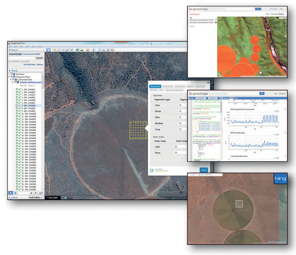
Figure 3: Built on Google desktop and cloud
computing technologies, Collect Earth
facilitates access to an unparalleled amount
of freely available archives of satellite
imagery, including very high resolution and
frequency imagery. Collect Earth streamlines
the use of probability sampling offering a
robust and fully customizable framework for
data collection. It allows the capture of new
information on agriculture and natural
resources for monitoring targets across the
2030 Agenda, from crop monitoring to land and
forest cover, from pest/locust control to
water management, from plant health to losses
due to natural disasters.
5.5 Country and international data for global
reporting: challenges and opportunities
Reaching the goals and targets of the
2030 Agenda for Sustainable Development requires
the establishment of global monitoring and
reporting processes. These processes should be
based as much as possible on national data in
order to ensure country ownership. In some
instances, however, international agencies may use
non-official data to construct international data
series in fields that are not covered by existing
official sources, or where a single source (e.g.,
EO satellite imagery) may provide more consistent
and lower-cost data to measure a global or
trans-national phenomenon than the results of
amalgamation of multiple individual country
datasets.
Non-official sources might
sometimes also be used by international agencies
to estimate country-specific values of SDG
indicators when national official data do not
exist, are incomplete or do not comply with
international standards; or to impute missing
values within a national official time series or
to extrapolate official time series. In this
respect, land, water and agri-environmental
statistics derived from satellite imagery support
the construction of a consistent data framework
across sub-national, national and global scales.
Figure 4: FAO and Global Strategy guidelines
on applying remote sensing information to
improve crop statistics.
As a result of this work, discrepancies
may arise between international and national
estimates of similar SDG indicators. This may be a
cause of concern for some national authorities given
the reputational risk for countries to have their
data contradicted by those published by
international organizations.
International organizations can address
these concerns by strengthening the statistical
capacity of countries in areas where data are not
available or not compliant with international
standards, with the goal of enabling them to produce
their own data in the long run. FAO’s activities
towards improved national statistics of its member
countries are an integral part of this effort. EO
and Big Data complement local knowledge and
expertise and can boost the efficiency, quality,
transparency, credibility and above all the
timeliness and efficacy of data collection and the
validation of existing global products.
Applications based on remote-sensing
data play a major role for building statistical
capacity in countries and for promoting knowledge
sharing at the regional level. FAO is offering
training on the use of FAO software tools such as
Open Foris and Collect Earth to national experts who
will be able to conduct – in a few hours – mapping
and classification exercises that used to take weeks
or months.
Article Contributors
Pietro Gennari, Francesco N Tubiello and Giulia
Conchedda (Food and Agriculture Organization of
the United Nations)
Further Information
FAO, Office of the Chief Statistician:
chief-statistician@fao.org