Environmental Information from Satellites in Support of Development Aid
Development Aid is a complex international system covering a range of financial aid mechanisms (loans, grants) originating from mostly Western industrialised countries to support the economic, environmental, social and political development of developing countries. About 80–85% of developmental aid comes from government sources such as Official Development Assistance (ODA), with the remaining 15–20% coming from the private sector, such as Non-Governmental Organisations (NGOs), foundations and other development charities. As an indication of the overall economic size of this activity, the total net ODA volume in 2016 was around US$143 billion, up 8.9% on 2015 figures.
11.1 Background and context
The 2030 Agenda for Sustainable Development is an action plan to take the bold and transformative steps that are urgently needed to shift the world onto a sustainable and resilient path. On 1 January 2016, the 17 Sustainable Development Goals (SDGs) of the 2030 Agenda officially came into force. These SDGs were adopted by world leaders in September 2015 at an historic UN Summit and will drive development aid priorities over the next few decades. A comprehensive governance process is in place within the UN framework to guide implementation of the 2030 Agenda, including the High-level Political Forum, the UN Statistical Commission (UNSC), the UN initiative on Global Geospatial Information Management (UN-GGIM), and many UN specialised agencies allocated as custodians of individual SDGs.
Many significant developments and changes are taking place in Earth observation (EO) that are bringing this technology from scientific use to a level where it can be used as an operational source of environmental information in a wide range of (non-specialist) domains. In addition, political, public and scientific interest is growing to make better environmental decision-making through the use of EO to address the grand societal challenges that the world is increasingly facing, many of which are linked to initiatives supported by the Group on Earth Observations (GEO).
Over the last decade, several space agencies have started individual initiatives to demonstrate the capabilities and use of EO in the field of development aid with varied stakeholders. These include the International Financing Institutions (IFIs), Multi-lateral Development Banks (MDBs), national aid ministries/departments, NGOs and a range of local government organisations in those developing countries that are the aid recipients. Such initiatives include NASA’s SERVIR program, based on a high-level partnership between NASA and USAid, and JAXA’s (Japan) active support and engagement with the Asian Development Bank (ADB). Since 2010, ESA has been collaborating on the use of EO-derived information together with leading IFIs, in particular in partnership with the World Bank (WB), the European Investment Bank (EIB), the International Fund for Agricultural Development (IFAD) and the ADB.
11.2 ESA initiatives
ESA has sought to demonstrate the benefits (both quantitative and qualitative) that EO can deliver in wide range of individual development aid projects implemented by the IFIs. EO can provide key environmental information (e.g., land, marine, atmosphere) to support the planning, implementation and monitoring of these projects in the IFI lending operations, many of which are large infrastructure investments. This information is tailored to the specific project requirements defined through close dialogue with the Bank project managers and, as such, is produced by specialist EO service providers (e.g., SMEs in Europe). For more details, see: www.worldbank.org/earthobservation.
These initial experiences have raised interest within the IFIs to explore a longer-term, more strategic approach to the integration of EO in their activities. For example, both the WB and ADB have signed strategic Memoranda of Intent (MoI) with ESA to collaborate more closely in ten priority thematic areas: Urban Development, Marine Resources & Coastal Environment, Agriculture & Rural Development, Disaster Risk Reduction, Energy & Extractives, Water Resources Management, Forest Management, Ecosystems Services, Fragile & Conflict States, and Climate Resilience & Proofing.
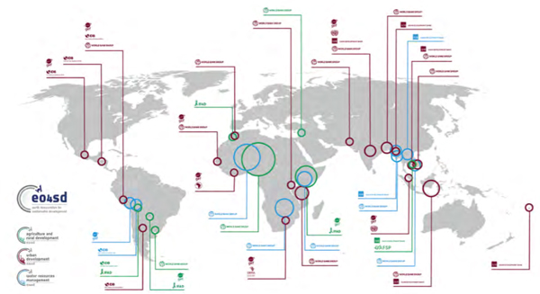
ESA’s Earth Observation for Sustainable Development (EO4SD: eo4sd.esa.int) initiative seeks to scale up the level of activity in each of these thematic areas by carrying out regional demonstrations over a 3-year period in two or three key regions around the world and two or three countries in each region. An important element will be building technical capacity within the government agencies of the countries involved, such that the environmental information derived from satellites can be effectively used in the local operations with a view to their long-term, sustainable usage. In 2016, ESA started larger-scale activities in three thematic domains (Urban Development, Agriculture and Rural Development, Water Resources Management), and has begun work in the remaining areas as of 2018. Requirements for information are being strongly driven by the relevant Bank teams, primarily within the WB, ADB, and IFAD (Figure 1).
Figure 1: Geographic distributions for the Areas of Interest (AoIs) addressed in the on-going ESA activities in Urban Development, Water Resources Management, and Agriculture & Rural Development.
11.3 Urban development
Efforts by governments and international development agencies to effectively ensure that urbanisation in developing countries takes place in a sustainable, equitable and inclusive manner are often hindered by lack of data. While it has been established that urban areas across the developing world are expanding rapidly, very often relatively little is known about the ways in which they develop in terms of spatial growth, pattern and associated population density.
Addressing the socioeconomic challenges in urban areas, including the uncontrolled formation of informal settlements, requires up-to-date and accurate spatial information. This includes information on the distribution and expansion of urban land and qualitative changes in land use. In this context, satellite data have significant potential to deliver un-biased urban-related information at global, regional and local scales.
Discussions with the IFIs have identified several priority requirements for information to support urbanisation programmes. These requirements can also be illustrated and structured adequately using the World Bank Group’s ‘plan–connect–finance’ framework developed for sustainable urbanisation. The requirements translate into a portfolio of EO products, the details of which can be found at eo4sd.esa.int/urban.
An example is in support of the Kolkata Environmental Improvement Investment Program, implemented by the ADB. This focuses on water supply and sewerage to the municipality, with the main stakeholder being the Kolkata Municipal Corporation (KMC) and also including the Kolkata Metropolitan Development Authority (KMDA) representing 19 municipalities and various state-level administrations.
In line with the Millennium Development Goals followed by India, in June 2015 the government launched three major urban development initiatives, handled by the Ministry of Urban Development (MoUD), in addition to several other programs such as the National Urban Information System (NUIS) initiated in October 2014. In this context, the KMC leads different projects for improving land-use management and urban planning in a sustainable manner.
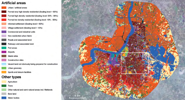
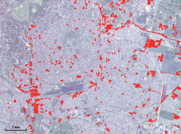
In Figure 2, the top panel shows the Land Use and Land Cover (LULC) product for Kolkata. The classification is based on the European Commission’s Urban Atlas nomenclature. For the core urban area, the LULC product used very high resolution (0.5m) Pleiades-1A/1B satellite imagery from the period 7–15 February 2017. The peri-urban areas were classified using Sentinel-2A (10m resolution) data, acquired on 16 March 2017, also shown as the background image. The bottom panel shows an extract of the informal settlements class, delineated via visual interpretation, based mainly on attributes of compactness, patch size and building density.
According to Neeta Pokhrel, Senior Urban Development Specialist working in the Kolkata programme, the EO4SD-Urban products can be very helpful for the KMC and other stakeholders for in-depth analysis of the city, both as mapping products and derived geo-statistical indicators. They can contribute to land-use planning (e.g., with precise mapping of informal settlements), better handling of disaster management and supplementing climate resilience assessments.
In support of a similar ADB program, EO-based mapping products were delivered over a number of urban areas in Cambodia’s Tonle Sap Basin. The ADB project officer (Sameer Kamal, Urban Development Specialist) explains that the overall goal of the program is to support the government of Cambodia in improving urban services and enhanced climate resilience in participating towns. The program is part of ADB’s sequential, programmatic engagement in Cambodia’s urban sector. The EO products are being used for both on-going and upcoming ADB projects to (i) inform urban land use and master planning, (ii) support the feasibility studies and detailed designs for specific subprojects, and (iii) prepare assessments of climate vulnerability, risk and adaptation to climate change.
Comprehensive monitoring of water bodies is essential for national water resources management in support of activities such as drought mitigation, irrigation management and planning of infrastructure investment (e.g. dam constructions). Information on the seasonal dynamics of small water bodies is a high priority requirement for river basin organizations such as the Zambezi Watercourse Commission (ZAMCOM) and its riparian member states (Angola, Botswana, Malawi, Mozambique, Namibia, Tanzania, Zambia and Zimbabwe). It is also important for reporting on the efficiency of water use for crop production (SDG Target 6.4).
The government’s measurement of water resources in the Zambezi region is limited to major dam resources and river flow stations, representing only a small portion of the overall water resources in the Zambezi countries where substantial amounts of water can be stored privately (e.g., in farm dams). These un-monitored water resources represent a significant gap in information and can contribute substantially to inaccuracies in water resource assessments, thereby increasing supply risk for users dependent on these resources. Assessing the dynamics of the complete set of water resources using regular and systematic EO data over the course of the season provides an efficient tool for planning, decision-making and supply risk reduction.
This information is being actively used in the context of the World Bank’s Zambezi River Basin Management Project, the objective of which is to strengthen ZAMCOM’s role in promoting cooperative management and development within the Zambezi river basin. Initial financing comes from a multi-donor trust fund (MDTF) for Cooperation in International Waters in Africa (CIWA) for the coming three years. The longer-term plan is to have this complemented by other funding sources for a pipeline of development projects to be implemented over a 10–15 year period.
11.5 Agriculture and rural development
In Morocco, IFAD supports the implementation of the Green Morocco Plan in mountainous areas through the Atlas Mountains Rural Development Project (PDRMA). Agriculture is a strategic sector within this Project both economically and socially. Food supply depends mainly on rainfall with large inter-annual variations, with only 20% of the croplands irrigated and limited weather risk mitigation and crop improvement opportunities available.
The PDRMA aims to reduce poverty in areas of the Atlas Mountains and increase agricultural production in three provinces of Ouarzazate, Tinghir and Béni Mellal. To understand the connections between rural communities and markets, and to answer key development questions in relation to IFAD activities, a holistic view of the mountainous regions is necessary. Questions include: How well are the agricultural areas connected to markets? Have bare lands been transformed for agriculture? Can degradation in rangelands be halted? Which areas are most prone to soil erosion? How does the Green Morocco Plan impact the environment?
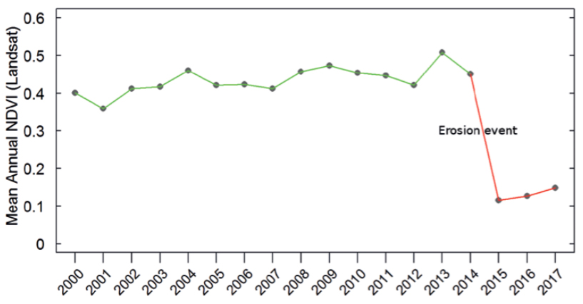
EO offers the opportunity to assess the status of natural and agricultural resources, focusing on evolution over time, land regeneration and assessment of improved natural resources management and conservation, contributing to more sustainable income sources for local populations. Land cover assessment enables monitoring of the location, changes and expansion in agricultural areas, for example the planting of fruit trees that is financed through PDRMA. It enables monitoring of changes in the rangelands that stabilise erosion-prone slopes and feed ruminant livestock and the identification of degraded or degradation-prone areas that can become target priorities for land management investment. Soil erosion along rivers and the loss of productive capacity (degradation, overgrazing) of rangelands are the two main issues facing agriculture in PDRMA areas.
Long-term time series of vegetation trends provide insights into historic evolution to highlight areas with significant negative trends. Soil erosion maps will combine information about the actual land cover with terrain, soil and rainfall information, indicating areas that are prone to water-based soil erosion, as well as those impacted by drought conditions and/or susceptible to drought. This provides baseline information and serves as a tool for identifying the most needed intervention areas.
IFAD is increasingly committed to better serving its stakeholder groups and demonstrating results; tools like remote sensing can make a significant contribution in this area. For example, during project preparation, there is a need to understand the socio-economic and biophysical baselines, as well as issues that drive environmental and social vulnerability. During results monitoring and impact verification, IFAD strives to improve Monitoring and Evaluation (M&E) methodologies with reliable, consistent and coherent information.
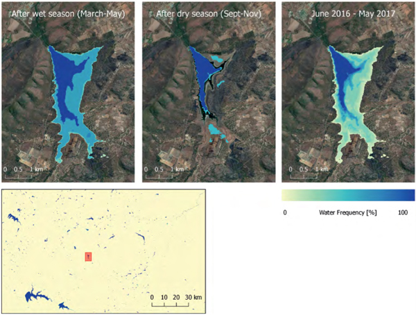
Figure 3: ZRBMP: Water Frequency (June 2016 - May 2017). Seasonal water body dynamics derived from 12-day Sentinel-1 time series in the Zambezi basin. Source: Contains modified Copernicus Sentinel data
11.6 Benefits that EO can deliver to development aid operations
Through this work, a number of benefits that EO can bring to development operations are beginning to emerge including:
− Increased efficiencies in existing operations through better use of resources (economic, manpower, time) with a globally consistent approach to implementation and monitoring activities, thereby reducing supervision costs;
− Improved definition of future operations through more informed development planning and methodologies, leading to better technical quality of projects and higher engagement of Client States;
− Extended capabilities by supporting policy formulation to allow environmental analysis in a way that is not possible by other means (e.g. impact of climate change); and
− Promoting better transparency, responsibility and accountability and impact evaluation through the use of open data.
The perceived potential for EO to support development activities is reflected in the following feedback received from some of the senior IFI partners involved in the ESA activities to date.
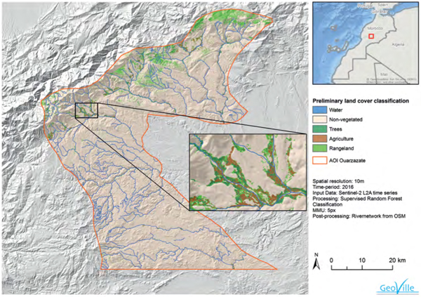
Figure 4: Detailed land cover/use mapping for 2016 in the Ouarzazate region (Morocco) based on Sentinel-2 imagery. Credit: EO4SD Agriculture Cluster. Source: GeoVille for ESA/IFAD, 2017, Contains modified Copernicus Sentinel data
“EO services bring a powerful analytical tool to the development context. They make you see the hidden and complex dynamics between the bio-physical and the socio-economic components of the livelihood systems; they make you reach better targeting and they make you see the difference you bring in the ground and in the lives of people”
Naoufel Telahigue, Country Program Manager, IFAD – Near East, North Africa, Europe and Central Asia Division)
“Satellites provide spatially explicit, consistent and comparable city-level observations. These observations have significantly reduced the uncertainty about the evolution of cities, creating the opportunity for better planning of infrastructure investments and services. The on-going collaboration with ESA is helping ADB to explore the value of Earth Observation-based maps and applying them in designing our lending projects.”
Vijay Padmanabhan, Director of the Urban Development and Water Division in ADB’s Southeast Asia Department and Chief of the ADB Urban Sector Group
“Earth Observation provides the development community with an unbiased, consistent and timely perspective that can inform data-driven decision-making. Geospatial data and analytics are increasingly considered key elements for making development policy and have proven to be effective in supporting the planning, implementation, monitoring and evaluation of Sustainable Development projects. It therefore helps us to achieve our core mission at the World Bank to eliminate extreme poverty and boost shared prosperity, and to better serve our clients. The well-established partnership with the European Space Agency is illustrating the value of EO-derived services for World Bank operations.”
Laura Tuck, Vice President, Sustainable Development, World Bank
11.7 Longer-term perspective
The overall objective of space agency investment in these activities is to ‘mainstream’ the use of EO-based information into development projects and activities, with the prospect of sustainable transfer into the working processes and activities of the main IFIs. This would mean EO-based information being planned into projects technically and financially as a systematic source of environmental information for all project phases: Identification, Preparation, Appraisal, Negotiation, and (most importantly) Implementation & Impact Evaluation.
‘Mainstreaming’ implies a significant capacity building activity to enable the full exploitation of EO, including Bank technical staff and management for the early project phases and (more importantly) the client country recipient (i.e., governments of developing countries) for implementation. Realising this in the complex and rapidly changing development aid system will require long-term, sustained efforts.
Promising initial results are being achieved, and awareness, interest and momentum is growing. At the 31st CEOS Plenary in October 2017, space agencies issued a statement underlining their joint commitment to developing a coherent strategy and approach to promote and expand the use of EO in the domain of Development Aid. It is hoped these efforts will help EO pragmatically work towards addressing the grand societal challenges the world is facing now, and is fully in line with the imperative goal for all governments to maximize the economic and societal benefits of investments in their EO observing systems.
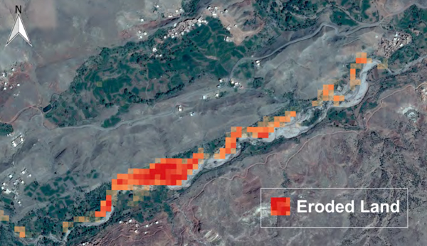
Figure 5: Disappearing agricultural lands due to river erosion near Ighrem N’Ougdal, Morocco. Source: DHI GRAS for ESA/World Bank, 2017
Article Contributors
Authors:
Stephen Coulson, Anna Burzykowska, Zoltan Bartalis, Benjamin Koetz, Christoph Aubrecht, Paolo Manunta (European Space Agency)
With contributions from:
Laura Tuck (Vice President, Sustainable Development, World Bank)
Vijay Padmanabhan (Director of the Urban Development and Water Division in ADB’s Southeast Asia Department, and Chief of the ADB Urban Sector Group)
CEOS - Earth Observation in support of Official Development Assistance (ODA): A Joint CEOS Agency Statement for endorsement at 31st CEOS Plenary, Oct 2017: goo.gl/GBqGEK