The Role of Geospatial Information and Earth Observations in the SDGs: A Policy Perspective
Data, as the basis for evidence-based decision-making, will be critical to the success of the 2030 Agenda. The broad and transformative nature of the 2030 Agenda has ushered in a new era in thinking about sustainable development, with renewed emphasis on countries being able to measure and monitor progress with good policy, science, technology and especially data. The unprecedented data demands and expectations relating to the SDGs necessitate new and innovative data sources, acquisition and integration approaches, and the need for “high quality, timely, reliable and disaggregated data, including Earth observations and geospatial information” to address development challenges and to “leave no one behind”.
Goal 17, in the area of data, monitoring and accountability, requires us by 2020 to “support developing countries to increase significantly the availability of high-quality, timely and reliable data disaggregated by income, gender, age, race, ethnicity, migratory status, disability, geographic location and other characteristics relevant in national contexts”. But do we really even understand the scale and dimensions of the world’s development problems, where they are, whom they impact, what the causes and consequences are, and how they can be remedied, let alone how to bring the data to bear to measure and monitor these complex and geographically interconnected problems?
1.1 Global Indicator Framework: measuring, monitoring and reporting on the SDGs
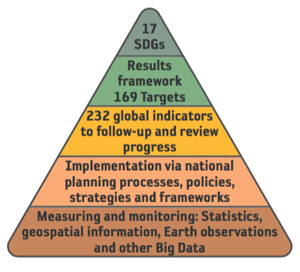
The 17 SDGs and 169 Targets provide the overall policy and results framework for the 2030 Agenda, but in terms of a robust and annual follow-up and review mechanism for its implementation, it is the Global Indicator Framework where the data acquisition, integration and disaggregation will be most needed. The task of determining the Global Indicator Framework was given to the UN Statistical Commission (UNSC). In 2015, the UNSC established the Inter-agency Expert Group on Sustainable Development Goal Indicators (IAEG-SDGs) to develop the Global Indicator Framework as the quantitative means by which national governments can consistently monitor achievement on, and report progress towards, each of the 169 Targets. In July 2017, the Global Indicator Framework was adopted by the General Assembly and comprises an initial 232 Indicators, which will be reviewed from time to time.
The United Nations Committee of Experts on Global Geospatial Information Management (UN-GGIM) and the Group on Earth Observations (GEO) worked closely with the statistical community, at a national and global level, to provide inputs into the processes to develop the Global Indicator Framework with the IAEG-SDGs. As depicted in Figure 1, key messages were that, while global in nature, implementation of the 2030 Agenda will still need to be ‘country owned and country led’ and through national development policies, strategies and frameworks. Through this process, statisticians now better understand that measuring and monitoring will require not only statistics, but also geospatial information, EO and other Big Data to provide new and consistent data sources and methodologies to integrate multiple ‘location-based’ variables to support and inform official statistics and the Indicators for the SDGs.
Figure 1: Measuring, monitoring and reporting on the SDGs will require new sources of data that are integrated, interoperable and coordinated.
By bringing together information from various sources, particularly those related to the environment, these data and analytical methods can fill data gaps and/or improve the temporal and spatial resolutions of existing data. This information integration is important, as the Indicator Framework will be the primary conduit to guide and inform Member States, based on individual national circumstances, on how they measure, monitor and report on the SDGs and related targets in the years to come. However, determining the Indicators is just the beginning, as they need to then be appropriately interpreted and implemented via national planning processes and frameworks, and guided by robust metadata and multidimensional data needs. Such data have the real potential of forming a new and emerging ‘data ecosystem’ for development, in which integrated information systems that are comprehensive and coordinated are able to monitor the state of the Earth, people and planet, and to deliver timely information necessary to citizens, organisations and governments to build accountability and make good, evidenced-based decisions from local to global levels.
To address these issues and specific areas relevant to SDG Indicator implementation, the IAEG-SDGs established a Working Group on Geospatial Information (WGGI) at its third meeting in April 2016. The WGGI – comprising statistical, EO and geospatial experts from national governments, academia and international organisations, including GEO – provides expertise and advice to the IAEG-SDGs and the broader statistical community as to how geospatial information, EO and other new data sources can reliably and consistently contribute to the indicators. The Working Group has now met four times and reports and provides updates to the IAEG-SDGs, the UNSC and UN-GGIM. There is also a close working relationship between the WGGI and the GEO Earth Observations in Service of the 2030 Agenda for Sustainable Development (EO4SDG) initiative.
1.2 Geographic location: the relationship between people, their place and their environment
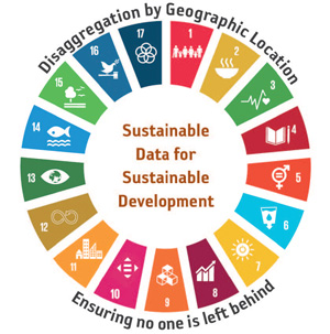
While the initial development of the Global Indicator Framework largely constituted a statistical data approach, the need for ‘disaggregation by geographic location’ in a new era of data needs is now well recognised by the IAEG-SDGs to ensure that no one is left behind (Figure 2). This is part of the mind-set change reflected in the 2030 Agenda; development is no longer only knowing about ‘people’ as national aggregations, but also their ‘place’ and their environment, their geographic location at a sub-national level. This then cascades into more detail. While having data that informs on the ‘how’ and the ‘what’ is valuable, such as how many primary schools are needed or what vaccines are being provided and in what volumes, it is profoundly better if we are able to also know the ‘where’ in order to provide geographic context and a richer understanding.
The effective use and integration of EO and geospatial technologies, combined with statistical and demographic data, enable countries to analyse and model where conditions are changing; create maps and other visualizations; evaluate impacts across sectors and regions; monitor change over time in a consistent and standardized manner; and improve decisions, policy and accountability. These outcomes can have a transformational impact on many of humanity’s most significant challenges in the developing world, such as helping global scientists, resource and planning managers and politicians better monitor and protect fragile ecosystems; ensure resilient infrastructure; manage climate risks; enhance food security; build more resilient cities; reduce poverty; and improve governance. Data is essential for informed policy-making, decisions and actions. Data allows us to know the how, what, when and where for the successful implementation and monitoring of the SDGs.
However, we still need to democratize these technologies and liberate the associated new and alternative data sources and methodologies in such a way that they are easily reachable and useable by developing countries. To succeed in our global development aspirations, we need to go beyond the developing countries to reach the poorest of the poor in the least developed countries. Historically, relatively little attention has been paid to the challenges these countries face in effectively collecting and producing data and in building and strengthening their capacities within the national mapping agencies and statistical offices. With the enabling global mechanism of the 2030 Agenda, the challenge is how to most effectively transfer the available technology, data richness and connectivity to the technology and data poor.
Figure 2: Sustainable data for sustainable development – the new data needs demand disaggregation by geographic location in order to ensure that no one is left behind.
1.3 The problem: where is the data?
In the second annual report on global sustainable development progress: Sustainable Development Goals Report 2017, released in July 2017, the United Nations Secretary-General stressed that high-level political leadership and new partnerships will be essential for sustaining momentum, underscoring the need for reliable, timely, accessible and disaggregated data to measure progress, inform decision-making and ensure that everyone is counted. Two years into reporting progress on the SDGs, the Global Indicator Framework has been determined and the production of Indicators for the review and follow-up on the implementation has begun in earnest. Against this backdrop, how are we progressing, what is the role of geospatial information and EO, and where is the sustainable data for sustainable development?
Firstly, let us consider the availability of EO and geospatial ‘data’ needed to measure progress, inform decision-making and ensure that everyone is counted. More observations and geospatial data are being acquired and made available than ever before, with petabytes being generated every day and growing exponentially. But are we yet bringing the science and data into the development processes in a timely and reliable manner – are we ‘industrializing’ our capabilities? Perhaps not yet. Unfortunately, phenomenal data volumes, computing gains and processing speeds does not necessarily, or easily, translate into useable information, knowledge and decisions at the fingertips of decision-makers. Further, while the most developed countries are grappling with an abundance of data, a data deluge, in many parts of the world data scarcity is still the norm. Additionally, the data deluge is not being matched by our ability to apply the appropriate analytics and modelling in a commensurate manner in order to make informed and timely decisions. This particularly applies to the Earth sciences and environmental modelling, which are incredibly complex systems in themselves. In order to be robust and rigorous, there is either a long time lag in analytical outcomes or a compromise in quality. Then when the data is available, there are still data access and discovery challenges – it may be incomplete; distributed across multiple agencies; not accessible, interoperable or standards based; and then there is the reality that, with such big datasets, internet bandwidth remains a major impediment for developing countries.
This brings us to the continuing policy dilemma. The EO and geospatial information environment is one that is dynamic, innovative and growing at a rapid rate in data quantity, quality and applicability. Advancements in acquisition techniques and technologies have led to the proliferation of sensors that collect information on smaller platforms, at higher resolutions and repeat rates, faster and in larger volumes. Billions of dollars in space infrastructure, with public and private sector investments, are being realized, giving the world the capability to provide sophisticated, continuous and sustained observations of the entire planet. Practitioners and scientists are familiar with the application of these observations to the task of forecasting, tracking, and alerting society, but this is still not well understood within governments at the policy level when it comes to providing practical development solutions and outcomes.
An impediment continues to be demonstrating how we translate and communicate our data inputs and real-time monitoring into intelligent information outputs that are both understandable and actionable at all levels – from local to global – and which provide a means to make consistent evidence- and science-based decisions. There is no denying that EO and geospatial information are essential operational tools, but still seen as a novelty when it comes to policy and decision-making. Therefore, how do we make these capabilities necessary and invaluable – to the point that countries cannot make decisions without their inputs – forming a new and emerging data ecosystem for development?
1.4 The solution: connecting policy with ‘data’ through the SDGs
Many countries still need considerable guidance and support as to how they can actively contribute to the implementation of, and track progress on, the SDGs. While there is an increasing realization of the relevance and application of EO and geospatial information for the production of specific Indicators, and more so when we consider data disaggregation and sub-national data, we need to be more aspirational and proactive to strengthen countries’ capabilities in integrative national information systems that facilitate and enable a growing data ecosystem that leverages an accessible, integrative and interoperable local-to-global system-of-systems.
While the global Indicators presently provide the national to global reporting outcomes, the future success of the global development agenda will be dependent on data – not whether it is statistical, EO, geospatial, environmental, economic, health, demographic, education or other data – just data! As we are seeing with consumers and users in civil society, it may no longer be a necessity for governments to know exactly where the data they are using and consuming has come from or who has generated it. They will just want assurances that it is authoritative, reliable, repeatable, the best available and fit-for-purpose to make the right decisions and policy. Such outcomes will require data to be more open, platforms to be more usable, analytics to be more accessible and systems to be more integrated. If this is achieved, we will see fundamental EO, geospatial information, positioning infrastructure, policy frameworks, institutional capacity and economic development moving up the value chain in all countries, including at the policy level.
The future reporting needs of the Global Indicator Framework will have to consider disaggregated data, from the sub-national to national level, while also allowing for aggregated global reporting that builds directly on the national data developed by countries, as well as that from custodian agencies. Additionally, national level indicators will be developed by countries, and likely not be produced by each country in the same way. The good news is that the statistical community is familiar with data aggregations and national data, while the EO and geospatial communities are familiar with data disaggregation and sub-national data. With a unique understanding of context and circumstances, and allowing for incremental improvement, our combined professional expertise is well positioned to contribute to measuring and monitoring the SDGs and tracking annual progress with EO and geospatial information.