Building a Demand-Driven Approach to the Data Revolution for Sustainable Development
The Sustainable Development Goals (SDGs), and the related implementation and monitoring agenda that governments are starting to address, have increased awareness of the huge demands for data, both to provide the raw material for the monitoring framework and also as an essential part of the infrastructure for delivering the goals. The expectations of governments are high and rising. Running an effective health or education service, understanding how to raise agricultural productivity or how to incentivise investment in new industries all require huge amounts of data for governments and other stakeholders to make effective decisions and implement good policy.
In response to both the increase in the demand for data and to new opportunities on the supply side, the Global Partnership for Sustainable Development Data (GPSDD) was launched during the United Nations General Assembly in September 2015 to support countries around the world and stakeholders across sectors to better harness the data revolution to achieve the SDGs.
10.1 Introduction
One of the most critical conditions for the realisation of the ambitions expressed in the Agenda 2030 will be the more effective and efficient use of dynamic and disaggregated data for improved decision-making, service delivery, citizen empowerment, entrepreneurship, competitiveness and innovation to help achieve and monitor the SDGs and their targets.
This increase in demand has come together with a huge increase in supply, driven by new technologies and the new methods that are now possible. There is a transformative ‘data revolution’ underway, by means of which “… new technologies are leading to an exponential increase in the volume and types of data available, creating unprecedented possibilities for informing and transforming society and protecting the environment. Governments, companies, researchers and citizen groups are in a ferment of experimentation, innovation and adaptation to the new world of data, a world in which data are bigger, faster and more detailed than ever before” (A World that Counts, 2014, p.2).
The creation of a partnership like GPSDD had been a recommendation of two reports (High-Level Panel on the Post-2015 Development Agenda and the Inter-Agency and Expert Group on SDG Indicators) produced under the auspices of the UN Secretary General during the post-2015 development process, which was then taken up by a number of governments, companies and civil society organisations to get the partnership launched in 2015. The GPSDD now has over 250 members including vanguard governments, international agencies, private sector companies, civil society groups, and statistics and data communities from all corners of the world, spanning sectors and disciplines.
The Global Partnership exists to connect different stakeholders working on data, to catalyse ideas and innovations that generate progress and solve problems, and to drive the political changes that are needed if data is to play its role as a key part of the infrastructure for sustainable development.
10.2 Data roadmaps for sustainable development
At the national level, a central pillar of the GPSDD’s strategy is to work with governments and other organisations to support their priorities for investments and innovations in data. The GPSDD does this by engaging with them in ‘data roadmap processes’ that are country-led and take a whole-of-government and multi-stakeholder approach (Figure 1).
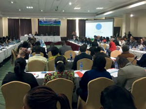
Figure 1: The Data Roadmap for Sustainable Development Forum held in Accra, Ghana in April 2017.
Accordingly, the data roadmap, in the current context, can be defined more as a process bringing stakeholders together at the country level to make progress against the SDGs, as opposed to a specific document outlining the path forward. While this is the intent of the process, using a multi-stakeholder approach to drive a strategic process that leads to clear actions over a defined timeframe, countries have used this process to organize, define priorities, connect with relevant partners, and better understand what is happening at the country level. In addition, the data roadmap process as defined by the GPSDD is meant to complement and align to other national development strategies including the National Strategy for Development of Statistics. Countries engaged as part of the data roadmaps process in 2016–2017 include Colombia, Philippines, Senegal, Sierra Leone, Kenya, Tanzania, USA and Ghana.
The GPSDD operates at three main levels:
1) putting data on the political agenda;
2) creating mechanisms to better connect demand with supply; and
3) creating an enabling environment to lessen the friction for data flows.
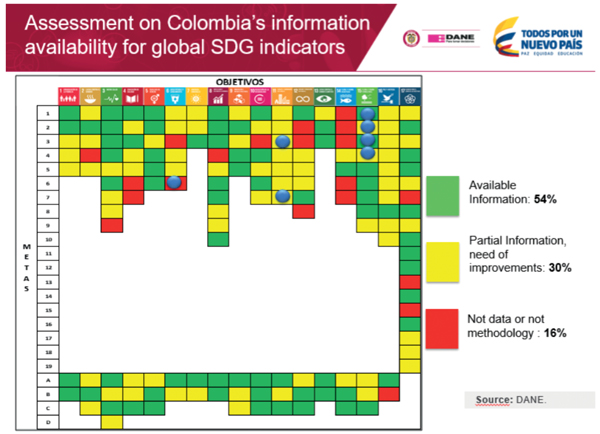
With these objectives in mind, the data roadmap process is very demand focused. It allows for the better understanding of how countries are addressing the SDGs in relation to their national development priorities; key issues and challenges around data and technology (Figure 2); and how alternative sources of data and new methods in the context of the data revolution can be applied to meet these challenges.
Figure 2: Data gaps assessment matrix for the SDG Indicators developed by DANE for Colombia in 2016.
10.3 Country needs – geospatial and EO data
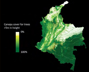
At the country level, the GPSDD has been working primarily with the National Statistical Offices (NSOs), Presidential Offices, Ministries of Planning and Finance, and institutions focused on the rights to information access as the main focal points through which other government institutions and stakeholders across sectors are brought into the process. A number of consistent challenges have been identified, including financing and capacity, interoperability, data-sharing mechanisms, engagement with the private sector, data literacy, and a number of others that will be outlined in a forthcoming report from the GPSDD assessing the data roadmaps process thus far. Of these, issues around data disaggregation, gaps on environmental data, and the use of geospatial and Earth observations (EO) have been identified as major issues that will be addressed by the GPSDD through multi-stakeholder collaborations (Figure 3). In addition, the GPSDD has been assembling a ‘Data4SDGs Toolbox’ that makes available a number of resources that speak to best practices, guidelines and tools that address many of the common challenges countries are facing within the context of the data revolution.
In early 2017, the GPSDD started working closely with NASA and the Group on Earth Observations (GEO) to more specifically address how EO and in-situ data could be applied to data gaps that countries are facing. Many of these are within the broader environmental domain and many of the targets and related indicators are classified as Tier II or III. With the support of NASA, GEO and other organizations including the University of Maryland, CEOS, ESA, CIESIN and University of South Florida, the GPSDD has been working iteratively to identify the need at the country level and match this need with available or developing methods from partner organizations in a way where these methods can be tested and scaled across countries (Figure 3). The United Nations Committee of Experts on Global Geospatial Information Management (UN-GGIM) is spearheading the process to better integrate geospatial methods with national statistics, something that this work at the country level is only further encouraging and aligning to.
For example, in Colombia, the GPSDD worked closely with NASA and the National Administrative Department of Statistics (DANE) to develop a workshop in March 2017, bringing together key institutions to address how EO data could be applied to generate and/or complement environmental information. The workshop included the Ministry of Environment and Sustainable Development (MADS) and the Institute of Hydrology, Meteorology and Environmental Studies (IDEAM), both of which had relevant expertise within this domain. Key SDG Goals identified as challenges included Goal 6 – Clean water and sanitation; Goal 11 – Sustainable cities and communities; and Goal 15 – Life on land.
Figure 3: Canopy cover of trees in Colombia >5m in height - Matt Hansen, University of Maryland.
With the help of all of the above institutions, a number of methods were identified that were applicable to strengthen the work already being done in the country, as well as new opportunities to address the needs of Colombia through partner organizations. More importantly, this process also supported the strengthening of institutional ties between the Colombian institutions regarding the dissemination on methods under development and promoting access to a Data Cube already under development at IDEAM with the support of CEOS, NASA and others, from open source code made available by Geoscience Australia and CSIRO. This process provided a great example of both national level and international collaboration, including making innovation more openly accessible.
10.4 Encouraging a data ecosystem approach
At the core of the work with country partners is the advancement of mechanisms for how governments, civil society, private sector and other actors including international organizations, foundations and academia work with one another to achieve the SDGs. It will take more coordination and cooperation across these sectors to fill the data and technology gaps, including the capacity and resources required. There are still fundamental issues when considering the elements needed to encourage a data ecosystem approach, including data sharing and federated approaches at the government level, and the integration of open data and the SDGs to build a more thriving environment that brings in the private sector and civil society as active participants and users of data. Conversely, both the private sector and civil society have valuable data in support of the SDGs that also needs to be made more accessible. For example, efforts are on-going for how mobile data, specifically call data records, can be applied for social good and the SDGs. However, there are many regulatory, privacy and functional models that still need to be developed and tested before this becomes more mainstream. Organizations like GSMA, DIAL, Orange, Dalberg Data Insights, MIT and many others are working on these issues. In the end: an ecosystem approach where the right policies are in place to encourage data sharing and open data; an infrastructure in place that creates a distributed network; and users across sectors that have access to use and innovate against these data developing a new market for social good is the ideal. The SDGs need a framework that supports the reporting and monitoring requirements, while also applying data for action, decision-making and entrepreneurship.
10.5 API Highways
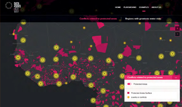
An early activity the GPSDD was involved in was to address the interoperability issues that limit access and use of data. A ‘Data Architectures’ Working Group was formulated in early 2016 that initially focused on the differences between platforms, rather than an infrastructure that supports the data needs of these platforms. As a result, and based on further feedback from Working Group members, the GPSDD Secretariat experimented with developing a data infrastructure that sought to identify high-value, alternative datasets (geospatial, EO, open data, citizen-generated-data, mobile data) made available via API Highways that could easily be consumed by other applications and platforms (Figure 4). This includes a playbook or key considerations for developing data services.
The intent was to provide an additional “channel” for SDG-relevant data that could be networked with other data infrastructures and platforms, bringing together both official and non-official data that would further empower the developer ecosystem to create rich apps and visualizations for action and decision-making. Working with GEO, the GPSDD is also testing this infrastructure to make methods and EO data more accessible and thus scalable across countries. For example, GEO, NASA and others are working with UN Environment on the methodology for calculating Indicator 6.6.1 – change in the extent of water-related ecosystems over time. The GPSDD is working with GEO to create a connector from API Highways to its data repository such that the data needed for this indicator can be ‘packaged’, along with the methods where API Highways can be used as an additional channel to scale the application of this method.
10.6 Conclusion
Over the next 3 years, many countries will be undergoing their national censuses both for population and agriculture. While maintaining the need for household level surveys, there are consistent needs for using alternative methods to make these censuses and sectorial information more dynamic, cost-effective and granular, something where geospatial and EO data have a large role. When coupled with citizen-generated data, mobile data and survey level data, there is immense potential for how these data not only inform national planning, but also citizen-level decision-making.
Figure 4: An example of bringing data together via API Highways to visualize where conflict is occurring in relation to protected areas.
Article Contributors
Aditya Agrawal (Director, Data Ecosystems Team, Global Partnership for Sustainable Development Data)