EO4SDG: Earth Observations in Service of the 2030 Agenda for Sustainable Development
The Earth Observations for the Sustainable Development Goals (EO4SDG) Initiative organises and realises the potential of EO and geospatial information to advance the 2030 Agenda and enable societal benefits through achievement of the SDGs. In particular, the Initiative aims to advance a portfolio of national pilot projects in one or more GEO Member countries focused on integrating EO with national statistics to better measure, monitor and achieve the SDGs. Supplemental implementation mechanisms include: capacity building activities to help provide support to institutions and individuals in the use of EO methods and data to achieve the SDGs; dissemination of data and information products to advance the provision, access, discoverability and applicability of EO for use with the SDGs; and outreach and engagement activities to promote the consideration and adoption of EO for the SDGs by nations and stakeholders. EO4SDG has also become a focal point for coordination across the breadth of the Group on Earth Observations (GEO) Work Programme including relevant Flagships, Initiatives and Community Activities.
7.1 Introduction
The multidimensional landscape of the United Nations (UN) 2030 Agenda for Sustainable Development requires GEO to engage with numerous UN activities, multi-stakeholder partnerships, emerging initiatives and voluntary commitments from all stakeholders devoted to support the SDG process. GEO is working to ensure comprehensive alignment and engagement of EO with the SDG implementation process through close collaboration with users and stakeholders including, but not limited to: GEO Members, Participating Organizations and Observers; National Statistical Offices (NSOs) and line ministries; and international organizations, UN Custodian Agencies, the United Nations Statistical Division (UNSD), the UN Committee of Experts on Global Geospatial Information Management (UN-GGIM), the United Nations Environment Programme (UN Environment), and the United Nations Convention to Combat Desertification (UNCCD).
Currently, GEO supports the implementation of the 2030 Agenda through:
a) Implementation of the GEO Engagement Strategy, endorsed at the GEO-XIII Plenary meeting in 2016, which identifies the 2030 Agenda as one of the three priority areas for coordinated engagement across the entire GEO community;
b) The EO4SDG Initiative; and
c) A GEO Programme Board-directed initiative that aims to ensure alignment among the GEO Work Programme elements and the GEO priorities, including the SDGs.
EO4SDG participates in the Inter-Agency and Expert Group on Sustainable Development Goals (IAEG-SDGs) Working Group on Geospatial Information (WGGI) and works to enhance its engagement with the UN, expand GEO’s current collaborations and ensure alignment with international coordinating organizations, foundations and initiatives, such as the Global Partnership for Sustainable Development Data (GPSDD), the UN Sustainable Development Solutions Network (SDSN) and the International Institute for Sustainable Development (IISD).
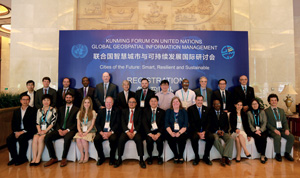
Figure 1: Third Meeting of the IAEG-SDGs Working Group on Geospatial Information, Kunming, Yunnan, China, 8-10 May, 2017
7.2 Engagement with the UN process
EO4SDG has a broad range of engagement with UN groups and agencies in support of Agenda 2030.
WGGI: WGGI aims to demonstrate the value of geospatial information and its contributions to the SDG Indicators and associated metadata. EO4SDG contributed to WGGI reports on Indicators 6.6.1, Change in the extent of water-related ecosystems over time and 15.3.1, Proportion of land that is degraded over total land area, that: summarized the current status of the two Indicators’ metadata; examined existing statistical practices; reported on current UN institutional activities; and described current techniques for geospatial data including EO that can be used to provide information on the Indicators.
EO4SDG also supported WGGI in the development of advice and guidance to the IAEG-SDGs on how geospatial information, EO and other data sources can reliably and consistently contribute directly or support the production of Indicators.
Figure 2: Access to safe water and sanitation and good management of freshwater ecosystems are essential to human health, environmental sustainability and prosperity.
UN Custodian Agencies: UN Environment, Custodian Agency for several Indicators under Goal 6 including 6.6.1, Change in the extent of water-related ecosystems over time, and 6.3.2, Proportion of bodies of water with good ambient water quality, has developed step-by-step methodologies to monitor factors that are associated with these Indicators, such as changes in water quality, water quantity and spatial extent. The methodologies provide an explanation of how to monitor these changes over time and include definitions, computational steps and recommendations on spatial and temporal resolutions. In collaboration with space agencies such as NASA, ESA and the European Commission’s Joint Research Centre (JRC), UN Environment is seeking to include EO components into Indicator methodologies for national and sub-national level data collection and monitoring that will:
– help generate a reference baseline against which change in spatial extent of water-related ecosystems can be measured and future monitoring can be compared; and
– provide maps and estimates of open water ecosystem extent in square kilometres using moderate and high resolution remote-sensing products, as well as water quality Indicators, such as concentrations of total suspended solids and chlorophyll-a products.
GEO representatives have also been extensively engaged with the UNCCD and the Food and Agriculture Organization (FAO), Custodian Agencies for several Indicators under Goal 15, Protect, restore and promote sustainable use of terrestrial ecosystems, sustainably manage forests, combat desertification, and halt and reverse land degradation and halt biodiversity loss, in their efforts to develop methodologies for monitoring degraded land through the use of EO techniques. UNCCD efforts relating to land degradation neutrality (LDN) have seen GEO support parties to the UNCCD in implementing the Convention by providing guidance on space-based information and in-situ measurements to assist countries in fulfilling the reporting requirements for SDG Indicator 15.3.1.
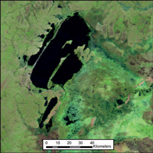
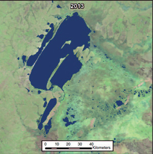
Figure 3: A) False colour composite (6-2-1) MODIS surface reflectance image (MOD09A11) of several lakes, the largest of which is Lake Bangweulu, and associated swamps in Zambia. Imagery is an 8-day composite collected from a period beginning on 7/12/13. B) The annual water dataset, MOD44W C6.1 (Carroll et al., 2017), overlain in blue, showing measured spatial extent of open water for the year 2013
7.3 EO4SDG support to countries in monitoring Targets and Indicators
The principle of national ownership is at the core of the 2030 Agenda to help ensure a people-centric approach that addresses national priorities. It requires countries to be chiefly responsible for collecting information and producing reports on monitoring progress towards the achievement of the SDGs. EO4SDG directly supports countries and pursues pilot projects that aim to develop and deploy uses of EO to support the tracking of, and reporting on, the SDGs. These projects conceive, develop, test and validate relevant methods, building on proven, existing techniques and applications, where appropriate.
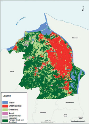
Partnering with the GPSDD and national agencies in Colombia, including the National Administrative Office of Statistics (DANE) and the Institute of Hydrology, Meteorology, and Environmental Studies (IDEAM), EO4SDG is devising a work plan to support the use of EO data products and tools to advance the tracking of, and reporting on, the SDGs in Colombia. The government of Colombia has successfully implemented several projects that demonstrate the value of using EO to monitor SDGs. DANE conducted a successful pilot project using EO to examine SDG 11, Indicator 11.3.1, Ratio of land consumption to population growth, using a method that incorporates freely available Landsat images with population statistics data to investigate the relationship between land consumption and population growth in four metropolitan areas (MA), including Barranquilla in northern Colombia. DANE has now measured this Indicator for more than 130 cities in Colombia. As a follow-up step, EO4SDG and partners are now working with DANE to extend the successful method to other countries, ensuring widespread sustained utilisation of EO data to track and monitor Indicator 11.3.1.
Figure 4: Land cover areas for the Baranquilla Metropolitan Area: year 2015. Credit: DANE Report
In addition, IDEAM has been using satellite data in their national forest monitoring efforts in support of the nationally led, Reducing Emissions from Deforestation and Forest Degradation (REDD+) effort. Further, IDEAM and the University of the Andes have made considerable progress in learning how to create and use data cubes – time series stacks of analysis-ready data. In collaboration with the Committee on Earth Observation Satellites (CEOS) Systems Engineering Office (SEO), a country-level Landsat Data Cube (consisting of 25,000 scenes) was completed in December 2016.
These efforts demonstrate the value and contributions of EO along with other data types to monitor and implement the SDGs at national level. Colombia is now working with EO4SDG and partners to identify ways to use EO to advance work on these topics and determine other areas of interest where incorporation of EO data can be beneficial. Additionally, DANE is interested in exploring further how EO can support the country’s upcoming census, including the need for official, reliable statistics and information about indigenous populations – their number, location, demographics, and agricultural activity, among other items.
In Africa, EO4SDG has also engaged with Kenya’s Ministry of Agriculture, Livestock and Fisheries, in close collaboration with GPSDD, to identify areas of EO contributions in support of national priorities and data needs. Coordination with the Governments of Kenya, Sierra Leone, Ghana, Senegal and Tanzania, as well as GPSDD, Safaricom, the African Development Bank and the UN Economic Commission for Africa, has aimed to establish an aspiring agenda to bring together the voices of African governments, local and regional bodies, private sector and civil society across the region to ensure that data becomes an integral part of the infrastructure for sustainable development, supporting improved economic, social and environmental decision-making.
The SERVIR program is a joint venture between the National Aeronautics and Space Administration (NASA) and the US Agency for International Development (USAID) that provides satellite-based EO data and science applications to help improve environmental decision-making in developing nations. In collaboration with AfriGEOSS, a GEO regional initiative that aims to provide the necessary framework for African countries, organizations and international partners to access and leverage ongoing EO-based initiatives across Africa, the SERVIR program is looking to leverage ongoing activities and explore linkages to support government needs on SDG monitoring and reporting efforts, using EO data.
7.4 Partnerships
The EO4SDG Initiative pursues partnerships as a key element of its strategic implementation, leveraging knowledge, resources and skills of partner organizations in collective support of the SDGs. Involvement of the individual GEO Member countries and Participating Organizations is central to the Initiative’s activities, including efforts to support the engagement of, and collaboration with, NSOs. The Initiative seeks to enhance GEO’s strong relationship with the UN and continuously engages and informs the global EO and geospatial information communities of developments and opportunities. Additional key partners of EO4SDG include development banks, non-governmental organizations, corporations, foundations and civil society.
Engagement and partnership with these entities help build processes, mechanisms and human capacity to include EO in national development plans and to integrate them with national statistical accounts to improve the measuring, monitoring and achievement of the SDGs.
Two examples of key organizations that EO4SDG is involved with, include:
Global Partnership for Sustainable Development Data (GPSDD): GEO has been a key Anchor Partner with the GPSDD, supporting GPSDD’s country-level data roadmap process that assists countries with developing and implementing whole-of-government, multi-stakeholder data roadmaps for sustainable development at both national and sub-national levels. EO4SDG is providing resources and expertise to more directly engage with countries on meeting key data gaps and challenges. Country examples include Colombia, Kenya, Senegal and Ghana, among others.
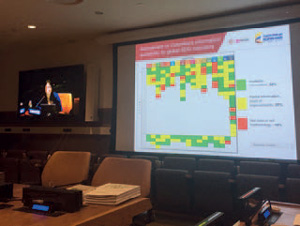
Figure 5: An assessment of the availability of Colombian information available for SDG Indicators (presented at the July 2017 UN High Level Political Forum learning, training, and practice session, co-organized by GEO and GPSDD)
EO4SDG has also been working with GPSDD on assembling a module on “Earth Observations for the Sustainable Development Goals” for inclusion in their Data4SDGs Toolbox, which comprises a set of tools, methods and resources to help countries create and implement their data roadmaps for sustainable development.
Examples of pilot efforts, capacity building, as well as outreach and engagement activities, in collaboration with the GPSDD, can be found on EO4SDG’s website, eo4sdg.org, under ‘What We Do’. An article by GPSDD can be found in Part 2 of this Handbook.
Sustainable Development Solutions Network (SDSN): GEO participates in the SDSN Thematic Research Network on Data and Statistics, TReNDS, which convenes cross-sector technical and policy knowledge from across the global scientific, development, public and private sector data communities. Its members are leaders whose expertise spans the spectrum of global and national data policies, standards and processes that guide data production, access and use. TReNDS aims to contribute critical insights and offer technical and policy-oriented solutions on the rapidly evolving sustainable development data ecosystem. GEO supported the production and review of a report, “Counting On the World”, which focused on recommendations about how to improve the global ecosystem for sustainable development data.
7.5 Concluding remarks
GEO envisions a world, well in advance of 2030, in which uses of EO and geospatial information to support progress on the SDGs are valuable, routine and customary. Realising this vision implies that:
- the global community is aware of, and has timely access to, effective ways to use EO and geospatial information relative to the SDGs;
- countries and stakeholders have developed the skills and capabilities necessary to apply the data and information for effective SDG monitoring and reporting;
- EO provide real, value-added benefits and are recognized for their contributions to support the social, economic and environmental aspects of the 2030 Agenda; and
- there is demonstrated progress on the Goals and broad desire to achieve more.
Finally, to accomplish this vision, focus must be given to the means of implementation and global partnerships among EO providers, stakeholders and countries and in particular for NSOs and line ministries to ensure that countries have the latest information at their fingertips to guide and shape policies.
To this end, EO4SDG and the GEO community has found that successful development and application of EO for SDG data and monitoring support in national and sub-national contexts requires the following elements:
- direct engagement with the UN Custodian Agencies to ensure EO techniques are incorporated in recommended data methodologies and early data studies as they are developed – this is especially important for Tier 3 Indicator methodologies (those under or needing further development);
- both direct and global development data partnership-enabled engagement with national governments;
- facilitation and encouragement for national government ministries and agencies to work together across traditional institutional lines to incorporate EO and data collection techniques beyond traditional statistical practices;
- framing EO and data collection in direct action contexts and examples demonstrating improved human well-being and policy at community and national levels.
GEO’s EO4SDG experience has provided some indications of the way forward for immediate progress. These include the following:
- specific focus on collaborative work across the development data ecosystem to incorporate EO techniques;
- prioritising integration of EO techniques with national census and newly emerging population data techniques, enhancing the ability of national and sub-national entities to GEO-locate and disaggregate gender and other demographic data;
- improving collaboration and integration of activities across the GEO and CEOS communities to make the most efficient use of intellectual, space-based and in-situ observation assets and resources;
- accelerated engagement among GEO and CEOS specialized communities to identify novel data analytics and observations that can result in better metrics and indicators.
Prepared by:
Argyro Kavvada, NASA/Booz Allen Hamilton & GEO EO4SDG
Argyro.Kavvada@nasa.gov
With contributions from:
Lawrence Friedl, NASA Earth Science Division & GEO EO4SDG Co-lead
Chu Ishida, JAXA & GEO EO4SDG Co-lead
Eduardo De La Torre, INEGI (Mexico) & GEO EO4SDG Co-lead