Pan-European Space Data Providers and Industry
Working in Support of the SDGs
Europe has two intergovernmental agencies
dedicated to satellite Earth observations (EO):
the European Space Agency (ESA) develops and
operates a diverse range of EO satellite
missions including the Sentinel series in
cooperation with the European Commission and the
Copernicus Programme, while the European
Organisation for the Exploitation of
Meteorological Satellites (EUMETSAT) focuses on
supply of weather and climate-related satellite
data to the National Meteorological Services of
Member and Cooperating States in Europe and
other users worldwide.
Both agencies
provide data streams (making best use of Earth
observations, satellite communications and
satellite navigation information) with
significant potential to assist with the
monitoring and reporting for multiple SDGs.
8.1 Pan-European space agencies and sustainable
development
ESA has been working in close
partnership with UN agencies since the World
Summit on Sustainable Development (WSSD) in
Johannesburg, in 2002. It supports the UN
Environmental Conventions (UNFCCC, UNCCD and CBD)
with international partners and financial
institutions like the World Bank to promote the
use of space data and technologies to support
sustainable development activities and programmes.
ESA has developed a programme that
comprises EO missions in three categories:
meteorological missions, scientific missions
(Earth Explorers) and the Sentinel satellite
missions for the Copernicus programme led by the
European Commission. All three categories of
missions have potential to contribute to SDGs.
EUMETSAT’s observations of weather,
environment and climate, along with its scientific
and technical expertise and support to
capacity-building also help make the UN’s
Sustainable Development Goals a reality.
EUMETSAT’s primary objective as an
intergovernmental organisation, as set out in its
Convention, is to establish, maintain and exploit
European systems of meteorological satellites,
taking into account, as far as possible, the
recommendations of the World Meteorological
Organization (WMO). A further objective is to
contribute to the operational monitoring of the
climate and detection of global climatic changes.
EUMETSAT is proud to be contributing
to the implementation of the 2030 Agenda through
provision of global, accurate, consistent and
timely observations of the weather, environment
and climate from space and of its involvement in
user training and capacity-building projects. The
use of its data and products saves lives, prevents
economic loss and supports sustainable development
and innovation.
8.2 SDG-2: Zero hunger
EO offers an alternative to
traditional survey-based methods for forecasting
regional and global crop yield. Managing the
health of livestock is one path to that goal.
ESA co-founded the VGTropics project, an
information system to manage animal health data
in data-sparse environments like developing
countries in Africa. Livestock survey planning,
livestock distribution, data analysis and
syndromic surveillance are all supported and
facilitated by a satellite network, including
satellite navigation, GPS units, satellite-based
telecommunication services and satellite EO.
Thus, VGTropics works to offset weak capacity in
some African countries to conduct diagnostics
and gather coordinated information. The
commercialisation of VGTropics started at the
end of 2015. ESA also contributes to the global
Group on Earth Observations Global Agricultural
Monitoring (GEOGLAM) initiative started by the
G20 Agriculture Ministers in 2011.
8.3 SDG-3: Good health & well being
During the Ebola crisis, ESA
supported hospitals through the International
Charter on Space and Major Disasters and helped
laboratories by providing them with satellite
data thanks to an inflatable satellite antenna.
This technology facilitated rapid and reliable
diagnosis. The so-called B-Life system,
developed within ESA’s Advanced Research in
Telecommunications Systems (ARTES) Integrated
Applications Promotions (IAP) programme, was
used to support the Ebola treatment centre in
N’Zérékoré, a remote area of Guinea. B-Life
enabled collaboration in real time between
on-the-ground emergency teams and St. Luc’s
Hospital in Belgium, allowing for treatment
plans to be modified as patient blood samples
were analysed. In December 2014, the B-Life
service was registered as part of the European
Emergency Capacity Response within the European
Mechanism for Civil Protection managed by the
European Commission.
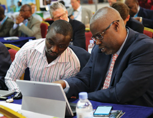
Figure 1: The 12th EUMETSAT User Forum in
Africa in Kigali, Rwanda, involves more than
160 participants from 51 African countries
in a workshop atmosphere
Figure 5: Copernicus services support coastal
zone monitoring and management.
8.4 SDG-4: Quality education
EUMETSAT supports training and
capacity-building initiatives in Africa, Eastern
Europe and Central Asia.
One example
is EUMETSAT’s uninterrupted support to a series of
highly successful EU-funded capacity building
projects (PUMA, AMESD, MESA, GMES & Africa)
involving the African Union Commission and
regional economic communities in the development
of weather, environment and climate information
services and an increasingly broad range of
applications that are central to sustainable
development.
Via its EUMETCast-Africa
data broadcast system, EUMETSAT provides access to
data from satellites and weather and ocean
forecasts information from a variety of sources to
more than 550 reception stations deployed across
the African continent.
EUMETSAT’s
record of effective partnership building and
multilateral and bilateral cooperation makes it a
trusted partner in capacity-building projects
facilitating the use of EO data and the building
of sustainable communities, industries and
environments.
8.5 SDG-6: Clean water and sanitation
In 2002, ESA worked with UNESCO to
launch the TIGER initiative to use EO technology
for improved, integrated water resources
management in Africa. Exploiting this technology
fills existing information gaps for effective and
sustainable water-resources management at
national-to-regional scales. Guided by its own
international steering committee, TIGER received
the endorsement of the African Ministerial Council
on Water. Today, the TIGER initiative aims to
support capacity-building activities and
development projects in some 42 African countries.
Delegates from 19 African and 10 European
countries participated in TIGER’s 2016 workshop
held in Addis Ababa.
8.6 SDG-7: Affordable and clean energy
The dependencies between energy,
weather and climate are increasing; while the
demand for energy remains temperature-dependent,
weather now determines the supply of the renewable
part of the energy mix. Therefore, weather
forecasts influence day-to-day decisions on energy
production while climate data are essential inputs
for well-informed decisions on strategic
investments in the energy sector, in particular on
preferred energy sources and production capacity.
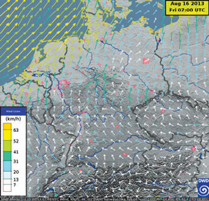
Figure 2: Forecast of surface wind field used
to guide operations of wind turbines and
predict their energy input to power grids. Source:
DWD
Observations from EUMETSAT satellites
have a twofold contribution as they increase the
performances of weather forecasts and are used to
produce climate records of solar radiation
parameters that can aid decision-making in
relation to solar energy installations.
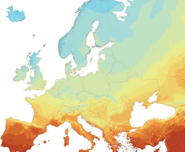
Figure 3: Map of photovoltaic solar
electricity potential based on Meteosat solar
irradiance climatology Source: JRC with
inputs from CM SAF
Missions like the Copernicus Sentinel
satellites provide increased potential to
characterise developments at urban scales. With air
pollution linked to millions of deaths around the
world, it has never been more important to monitor
the air we breathe. The Sentinel-5 TROPOMI
instrument will be very important to continue the
monitoring of our atmosphere by an operational
system. Delivering important data on the composition
of the atmosphere, Sentinel-5 is set to make a
step-change in monitoring and forecasting global air
quality. This state-of-the-art instrument will be
installed on the polar-orbiting MetOp Second
Generation satellite. It will monitor the
composition of Earth’s atmosphere globally on a
daily basis by measuring trace gases – such as
ozone, sulphur dioxide, methane and carbon monoxide
– and aerosols that affect air quality and climate.
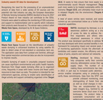
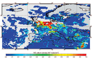
Figure 4: On 1 April 2014, the GOME-2
instruments on-board MetOp-A and -B observed
elevated levels of NO2 total column
concentration over parts of Germany, Belgium,
the Netherlands and the UK
EUMETSAT monitors atmospheric
composition from space using its geostationary and
polar orbiting satellites, which will in the future
carry additional dedicated Sentinel instruments
provided by the EU Copernicus programme.
These satellite observations provide key
inputs to forecasts of air quality over large urban
agglomerations as well as sand and dust storms, in
particular in Africa. Public health benefits from
the use of this information for regulating traffic
or other economic activities and for warning for
potential respiratory problems.
In
Europe, EUMETSAT data is used by the Copernicus
Atmosphere Monitoring Service (CAMS), which provides
information on air quality, the ozone layer and
harmful ultraviolet radiation to users worldwide.
EUMETSAT data and imagery are also used
for forecasting dispersion and transport of
accidental pollutions and to monitor wildfires and
the plumes of aerosols and gases they generate.
8.8 Further SDGs
Satellites have the unique potential for
observing systematically and globally 31 of the 50
Essential Climate Variables (ECVs) identified by the
Global Climate Observing System (GCOS). Both ESA and
EUMETSAT provide significant data in support of
SDG-13: Climate action.
For SDG-14: Life
below water, EUMETSAT monitors the oceans using its
own satellites, Copernicus missions it operates on
behalf of the EU and the Jason missions shared with
CNES, NASA and NOAA.
The resulting
integrated marine data stream provides information
about ocean currents, ocean surface wind, sea state,
sea ice, sea surface temperature and ocean colour.
These data are used directly and ingested in weather
and ocean prediction models to provide crucial
information for safety at sea, operations of marine
infrastructure, fisheries, sustainable use of marine
resources and protection of vital marine and coastal
ecosystems.
For SDG-15: Life on land,
optical imagery can be used to measure the extent of
different land cover types and their changes over
time, and can be complemented by radar data like
those from the Copernicus Sentinel-1 satellites and
Japan’s ALOS series. In the context of the Global
Forest Observations Initiative (GFOI), ESA
contributes to the REDD+ Initiative of the UN
Framework Convention on Climate Change (UNFCCC) to
support the availability of wall-to-wall national
coverage of satellite data to provide evidence and
accuracy for forest reporting.
8.9 EO industry contributions
Europe has a vibrant value-adding
industry that works in novel and creative ways to
improve society through the application of EO
satellite data. In 2017, the European Association of
Remote Sensing Companies (EARSC) decided to focus
its 2017 Product Award scheme on how industry might
support the SDGs with data from a wide variety of EO
sources. The results are the focus of the panel on
the pages below.
Article Contributors
Simonetta Cheli and Isabelle Duvaux-Bechon (ESA)
Paul Counet (EUMETSAT)
Monica Miguel-Lago (European
Association of Remote Sensing Companies)