Forging Close Collaboration Between EO Scientists
and Official Statisticians – An Australian Case
Study
EO data are increasingly being recognised by
official statisticians as an important data
source for the production of official
statistics. Since the establishment of the UN
Global Working Group on Big Data in 2015, the
relationship between official statisticians and
EO scientists has grown beyond Australian Bureau
of Statistics (ABS) and Geoscience Australia
(GA) in the use of EO data for environmental
accounts, to include the Commonwealth Scientific
and Industrial Research Organisation (CSIRO, a
member of CEOS), other Australian Federal and
State agencies and academics in the development
of an EO Handbook for official statistics, and
content for capacity-building workshops in Asia
and Latin America. The positive experience in
this collaboration not only increased the
understanding of official statistics production
and EO data sources, as well as its strengths
and weakness, but also provides a pathway for
more creative and productive use of EO data
between official statisticians and EO scientists
in the years to come.
3.1 Uses of EO data in Australia’s official
statistics
Australia’s decision-makers need
reliable information about changes in the use,
condition and value of land and how this relates
to broader economic activity and the state of our
environment. This information is used in policy
making and spending decisions in land management
and economic development. Official statistics are
well placed to provide this vital information by
integrating geospatial and environmental data with
a range of economic indicators.
The
ABS uses the UN System of Environmental-Economic
Accounting Central Framework (SEEA) to guide the
production of data concerning the environment and
economy. Land Accounts form the foundation of all
environment-economic accounts, and the ABS has
produced a series of Experimental Land Accounts
across several jurisdictions in Australia. Rather
than collecting the required data itself, the ABS
sources and integrates data from a number of
government organisations to produce these Land
Accounts.
An important input to Land Accounts is data
about land cover, both the biophysical cover and
the built environment. Through the application
of geoscientific expertise and capabilities, the
raw satellite observations can be used to detect
and map land cover.
The ABS currently works in
partnership with GA, which is also providing EO
services, expert advice and capabilities, and
information for decision-makers, to realise the
value of geospatial data and EO data to enhance
the production of official statistics in
Australia. A combination of high level
engagement and technical collaboration has
strengthened a productive and mutually
beneficial inter-agency relationship. This
national partnership has been critical in
ensuring that GA’s Dynamic Land Cover Data
(DLCD), a consistent national dataset of land
cover, has been available for the production of
Experimental Land Accounts. The use of the DLCD
time-series in Land Accounts provides a ‘line of
sight’ between EO data and the information
available to policy makers via statistical
products.
This has also motivated GA
to continue the production of DLCD. GA has
worked closely with the ABS on the release of a
new version of DLCD for Australia. This new data
became available in time for the preparation of
the Land Account: Queensland, Experimental
Estimates, 2011 – 2016 publication by the ABS,
which was released in June 2017.
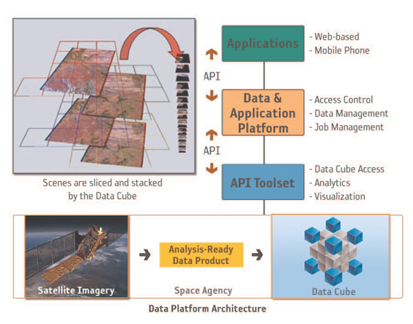
Figure 1: The Data Cube concept
3.2 A global platform for collaboration
The UN Global Working Group (GWG) on
Big Data for Official Statistics was created in
2014, as an outcome of the 45th meeting of the UN
Statistical Commission (UNSC). In accordance with
its terms of reference, the UN GWG provides
strategic vision, direction and coordination of a
global programme on Big Data for official
statistics, including for indicators of the 2030
Agenda for Sustainable Development. It also
promotes practical use of Big Data sources, while
supporting capability building, training and
sharing of experiences. Finally, the UN GWG
fosters communication and advocacy of use of Big
Data for policy applications and offers advice in
building public trust in the use of Big Data from
the private sector.
Between 2014 and
2017, ABS chaired the UN GWG and one of its Task
Teams (TT), Satellite Imagery (EO data) and
Geo-Spatial Statistics. Consistent with the
strategic vision and direction of the GWG, the ABS
TT decided at its early meetings to establish a
work programme to share best practice in using EO
data in the production of official statistics on
agriculture and environmental accounts, and to
host workshops in Asia and Latin America to help
build the capability of Asian and Latin American
National Statistical Offices in using EO data for
official statistics.
In developing the TT Handbook on EO
data, and in developing the content of the
methodology workshops (a trial run of which was held
in Canberra, Australia, in early 2017), official
statisticians from ABS worked closely and
collaboratively with EO scientists from CSIRO; GA;
Australian Bureau of Agriculture and Resource
Economics and Sciences (ABARES); and Queensland
Department of Science, IT and Innovation (DSITI);
and academics from the Queensland University of
Technology (QUT) chapter of Australian Research
Council Centre of Excellence in Mathematics and
Statistical Frontiers (ACEMS).
Throughout the Handbook, many case
studies and examples are showcased. In particular,
the SDG indicators were often referred to as
examples, since they appear as a unique opportunity
for EO and NSOs to work in close collaboration. As
such, forest monitoring – and especially
deforestation tracking to help achieve Goal 15 (Life
on Land) – is an example where EO brings a unique
contribution. The Global Forest Observations
Initiative (GFOI) of GEO, which relies on a few core
sub 30-m resolution satellite data sources, enables
a continuous, annual and global coverage to monitor
such indicators worldwide over the years. It will
thus directly help monitoring indicator 15.2.1
(Progress towards sustainable forest management).
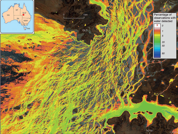
Figure 2: Water Observations from Space
(WOfS) results for the braided river network
of Coopers Creek in south-western Queensland,
Australia
3.3 Task Team Handbook
The TT led by ABS produced a Handbook
to provide guidance to NSOs about the use of EO
data, which include both satellite and in-situ
data, for official statistics. This was reviewed
by experts including the UN Food and Agriculture
Organization (FAO) and the Joint Research Centre
of Eurostat before being finalised in June 2017.
CSIRO played a significant role in
producing the Handbook as the primary authors of
Chapter 2, with some inputs from GA. The content
of the report has been driven by the direction
given by the UN Statistics Division (UNSD) for TTs
to produce a set of guidelines that include:
- Introduction that provides the
motivation and makes the business case, including
modernisation of official statistics and
monitoring the 2030 Sustainable Development Agenda
through the SDGs;
- Data sources –
description and explanation, as well as scope of
the guidelines;
- Statistical
methodology and applications;
-
Concluding section with further work to be done.
The report also outlines the TT pilot
projects and guidelines for practitioners
exploring the use of EO data for the first time.
The TT pilot projects described in the
report are:
- Pilot Study Proposal for
the application of satellite imagery data in the
production of agricultural statistics (ABS);
- Preliminary Analysis of
Climate Scenarios to Improve the Environmental
Characterization of Various Climatic Regions in
Mexico (INEGI, Mexico);
- Use of
satellite images to calculate statistics on land
cover and land use (DANE, Colombia).
The
crop yield work by Statistics Canada is also
included as an example of how satellite imagery can
be used in the production of official statistics in
practice. Statistics Canada is an NSO that has used
remote-sensing data since the early 1980s for
applications such as census and survey validation,
crop mapping and area estimation and support program
development. In 2016, Statistics Canada became the
first NSO to replace a statistical survey with a
remote-sensing model-based approach. The goal of the
model was to produce a preliminary estimate of the
expected harvest yield of the crops in late summer
using information from existing data sources.
ABS is also considering EO data for
statistical outputs as part of the larger
administrative data initiative and has received
presentations from Statistics Canada about their
methods and experiences. This has been very useful
to the ABS agricultural statistics area, the
Satellite Imagery TT report and EO workshop
development.
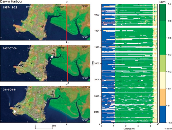
Figure 3: Darwin Harbour: representative
Landsat images and the time series along a
transect through the mangrove forest at
Frances Bay. White arrow: area of urban
expansion.
3.4 ABS, CSIRO and GA collaboration
Since the inception of the ABS TT,
CSIRO has been providing substantial inputs on a
number of dimensions of the Handbook, including EO
data sources available (besides the most common
MODIS and Landsat images), how to get access to
it, how to process and analyse it (using new
statistical methods and algorithms), and how ABS
and CSIRO can share and build on their expertise
to collect and use more satellite data to enhance
the official statistics for public good.
Through this collaboration, EO
concepts like ‘validity’, ‘accuracy’,
‘timeliness’, or ‘coherence’ and ‘analysis-ready
data’ (ARD), as well as the different EO sources,
their advantages and disadvantages, are adequately
explained in the Handbook to help official
statisticians make informed decisions on choices
of EO data for official statistics.
As
mentioned earlier, collaboration between ABS and
GA, which started in early 2000s, motivated GA to
develop the DCLD and resulted in the incorporation
of EO data in the ABS June 2017 release of a Land
Account publication.
This national and growing collaboration
(future projects includes Data Cube technology for
agricultural statistics in Australia) has provided a
tremendous opportunity to make EO data more
accessible, known and used by official statisticians
and hopefully showcases an example for similar
partnerships to be forged in other countries.
Following this initial positive
collaboration in the context of the TT, Australian
agencies including ABS, CSIRO and GA will continue
to pursue their efforts in working together and
bringing more EO data into the official statistical
framework and will continue to share their
experience and expertise in official statistics and
EO data to provide better information for
decision-making in Australia.
3.5 Concluding remarks
As ABS becomes more experienced with EO,
the organisation is committed to sharing this
knowledge with the international statistical
community and helping build the capability of other
NSOs in the use of EO data for official statistics.
In this exercise, ABS has found that
partnerships between EO scientists and academia are
important to progress the use of EO data for
official statistics. Through such partnerships,
developing and maintaining strong ties with
international organisations such as CEOS is
essential to successfully harness EO data for
official statistics.
Article Contributors
S.M. Tam, J. Holloway, R. Dunsmore, M. Jakab
(Australian Bureau of Statistics)