3.1 Satellite Earth observations
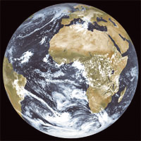
Since the first TV images of the Earth from space were transmitted by the TIROS-1 satellite back in 1960, humankind has recognized the benefits of this unique and global perspective of our home planet. There are currently 68 Earth observation satellite missions operating, and around 100 more missions, carrying over 300 instruments, planned for operation during the next 15 years or so by the world’s civil space agencies. An increasing number of commercial Earth observation satellites, which are funded, launched, and operated by industry, are also emerging to address important spatial information markets.
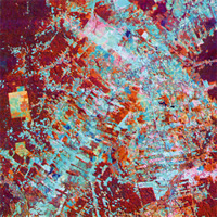
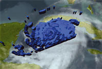
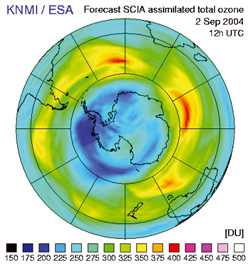
Space-based remote sensing observations of the atmosphere-ocean-land system have evolved substantially since the first operational weather satellite systems were launched. Over the last decade Earth observation satellites have proven their capabilities to accurately monitor nearly all aspects of the total Earth System on a global basis; a capability unmatched by ground-based systems that are limited to land areas and cover only about 30% of the planetary surface. Currently, satellite systems monitor the evolution and impact of the El Niño, weather phenomena, natural hazards, and extreme events such as floods and droughts, vegetation cycles, the ozone hole, solar fluctuations, changes in snow cover, sea ice and ice sheets, ocean surface temperatures and biological activity, coastal zones and algal blooms, deforestation, forest fires, urban development, volcanic activity, tectonic plate motion, and others. These various observations are used extensively in real-time decision-making and in the strategic planning and management of industrial, economic, and natural resources.
.jpg)
The proliferation of Earth observation satellites reflects their unique abilities and benefits, such as:
- inherent wide area observation capability: offering synoptic views of large-scale phenomena, and placing in-situ measurements in the global context required for the observation of many environmental and climatic phenomena;
- non-intrusive observations: allowing collection of data to take place without compromising national sovereignty in the way that ground-based measurements or airborne remote sensing might; this is an advantage in the context of use within international environmental treaties;
- uniformity: in that the same sensor may be used at many different places in the world (some of which are inaccessible, making in-situ measurements infeasible);
- rapid measurement capability: allowing sensors to be targeted at any point on Earth, including remote and hostile areas;
- continuity: with single sensors or series of sensors providing long time series of data suitable for climate studies.
Present-day applications of satellite data are widespread and cover research, operational and commercial activities. On a global scale, space-based systems make a considerable contribution to the collection of data required for climate change research, in providing high-quality, consistent, global datasets over long time periods for use in understanding the climate system, detection of potential anthropogenic change, validating climate models, and predicting future change.
Satellites are capable of obtaining global spatial coverage, particularly over the vast expanses of the oceans, sparsely populated land areas (e.g. deserts, mountains, forests, and polar regions), and the mid and upper troposphere and stratosphere. Satellites provide unique measurements of solar output, the Earth’s radiation budget, vegetation cover, ocean biomass productivity, atmospheric ozone, stratospheric water vapour and aerosols, greenhouse gas distributions, sea level and ocean interior, ocean surface conditions and winds, weather, and tropical precipitation, among others.
Earth observation satellite applications are not limited to meteorology, climate and environmental studies; Earth observation satellites deliver information to a broad range of sectors, providing significant economic, societal, and humanitarian benefits as a result, including:
- agriculture and forestry services utilise satellite data to provide, amongst other products, mapping information, crop health statistics, yield predictions, harvest optimisation, and estimated rainfall amount;
- resource mapping utilising very high resolution satellite data, when combined with conventional survey techniques, provides information needed to locate both renewable and non-renewable resources, such as mineral deposits, and a cost-effective means of mapping large, sometimes inaccessible regions;
- hazard monitoring and disaster assessment schemes are in place which incorporate satellite data to provide wide area coverage of, amongst other things, volcano plumes and areas stricken by drought or earthquake;
- commercial fishing industries routinely utilise satellite-derived fishing assessments to optimize their operations;
- ocean wave and current information is used by offshore exploration companies and shipping to improve operational safety and route-planning;
- mapping and urban planning agencies exploit satellite imagery for generation of maps and digital elevation models.
3.2 CEOS
What is CEOS?
CEOS is the Committee on Earth Observation Satellites, created in 1984 in response to a recommendation from a Panel of Experts on Remote Sensing from Space, under the aegis of the Economic Summit of Industrialised Nations Working Group on Growth, Technology and Employment.

CEOS was established to provide coordination of the Earth observations being provided by satellite missions – recognising that no single programme, agency, or nation can hope to satisfy all of the observational requirements which are necessary for improved understanding of the Earth System. Since its establishment, CEOS has provided a broad framework for international coordination on spaceborne Earth observation missions.
What does CEOS contribute?
CEOS strives to facilitate the necessary harmonisation and achieve maximum cost-effectiveness for the total set of space-based observation programmes of member countries and agencies.
CEOS has established three primary objectives in pursuing this goal:
- to optimize benefits of spaceborne Earth observations through cooperation of its Members in mission planning and in development of compatible data products, formats, services, applications and policies;
- to serve as a focal point for international coordination of space-related Earth observation activities;
- to exchange policy and technical information to encourage complementarity and compatibility of observation and data exchange systems.
The work of CEOS spans the full range of activities required for proper international coordination of Earth observation programmes and maximum utilisation of their data, and ranges from the development of detailed technical standards for data product exchange, through to the establishment of high level interagency agreements on common data principles for different application areas – such as global climate change and environmental monitoring.
Who participates in CEOS?
CEOS membership comprises most of the world’s civil agencies responsible for Earth observation satellite programmes – amounting to 24 Members in 2005. CEOS also has 20 Associates, comprising:
- governmental organisations that are international or national in nature and that are developing Earth observing satellite programmes or significant supporting ground facility programmes;
- other existing satellite coordination groups and scientific or governmental bodies that are international in nature and currently have a significant programmatic activity that supports CEOS objectives.
- The full list of Members and Associates is shown in the tables on pages 18 and 19.
CEOS On-line
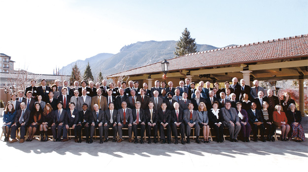
17th CEOS Plenary participants, Colorado Springs, November 2003
How does CEOS operate?
CEOS is managed by Plenary, at which CEOS Principals meet annually. The CEOS Plenary determines policy, reviews progress on the projects and activities being undertaken, and sets the agenda of activities for the upcoming year. The Chair of CEOS rotates at the annual Plenary.
The work of CEOS is conducted within its various working groups. Coordination throughout the year is maintained through a permanent Secretariat maintained by the European Space Agency (ESA) jointly with the European Organisation for the Exploitation of Meteorological Satellites (EUMETSAT), the National Aeronautics and Space Administration (NASA) jointly with the National Oceanic and Atmospheric Administration (NOAA) of the USA, and the Ministry of Education, Culture, Sports, Science and Technology (MEXT) jointly with the Japan Aerospace Exploration Agency (JAXA).
CEOS, IGOS-P and GEO
CEOS was one of the founding Partners that established the Integrated Global Observing Strategy Partnership. The principal objectives of the Integrated Global Observing Strategy are to address how well user requirements are being met by the existing mix of observations, including those of the global observing systems, and how they could be met in the future through better integration and optimisation of satellite remote sensing and in-situ systems.
Strengthened links between space-based and Earth-based observing systems, and with scientific and environmental policy-making processes, provide compelling motivation for CEOS to take an active role in IGOS-P activities, and CEOS has embraced the concept of an IGOS as a valuable initiative which perfectly complements its own set of objectives.
By working together, CEOS agencies are in a position to plan their Earth observation programmes with the minimum of unnecessary overlap and to devise joint strategies for addressing serious gaps in their observation capabilities. As GEO evolves (see section 2), CEOS expects to extend its efforts to support the space observation aspects of its Implementation Plan for a global system of systems.

More information
Further information on the membership, structure, activities, and achievements of CEOS is provided in Annex A of this document.
CEOS Membership
| Organisation |
Country / Countries |
| ASI |
Agenzia Spaziale Italiana |
Italy |
| BNSC |
British National Space Centre |
United Kingdom |
| CAST |
Chinese Academy of Space Technology |
China |
| CNES |
Centre National d’Etudes Spatiales |
France |
| CONAE |
Comisión Nacional de Actividades
Espaciales |
Argentina |
| CSA |
Canadian Space Agency |
Canada |
| CSIRO |
Commonwealth Scientific and Industrial
Research Organisation |
Australia |
| DLR |
Deutsches Zentrum für Luft- und Raumfahrt |
Germany |
| EC |
European Commission |
Austria, Belgium, Cyprus, Czech Republic,
Denmark, Estonia, Finland, France, Germany, Greece, Hungary,
Ireland, Italy, Latvia, Lithuania, Luxembourg, Malta, The Netherlands,
Poland, Portugal, Slovakia, Slovenia, Spain, Sweden, United
Kingdom |
| ESA |
European Space Agency |
Austria, Belgium, Denmark, Finland, France,
Germany, Ireland, Italy, the Netherlands, Norway, Portugal,
Spain, Sweden, Switzerland, United Kingdom. (Luxembourg and
Greece anticipated to become full members during 2005 Canada,
Hungary and Czech Republic are Cooperating States of ESA) |
| EUMETSAT |
European Organisation for the Exploitation
of Meteorological Satellites |
Austria, Belgium, Denmark, Finland, France,
Germany, Greece, Ireland, Italy, Luxembourg, The Netherlands,
Norway, Portugal, Spain, Sweden, Switzerland, Turkey, United
Kingdom. (plus 9 cooperating states: Slovak Republic, Hungary,
Poland, Croatia, Republic of Serbia and Montenegro, Slovenia,
Romania, Czech Republic and Latvia) |
| INPE |
Instituto Nacional de Pesquisas Espaciais |
Brazil |
| ISRO |
Indian Space Research Organsation |
India |
| KARI |
Korea Aerospace Research Institute |
Korea |
| MEXT/JAXA |
Ministry of Education, Culture, Sports,
Science and Technology / Japan Aerospace Exploration Agency |
Japan |
| NASA |
National Aeronautics and Space Administration |
United States of America |
| NASRDA |
National Space Research and Development
Agency |
Nigeria |
| NOAA |
National Oceanic and Atmospheric Administration |
United States of America |
| NRSCC |
National Remote Sensing Center of China |
China |
| NSAU |
National Space Agency of Ukraine |
Ukraine |
| ROSHYDROMET |
Russian Federal Service for Hydro-meteorology
and Environment Monitoring |
Russia |
| ROSKOSMOS |
Russian Federal Space Agency |
Russia |
| SNSB |
Swedish National Space Board |
Sweden |
| USGS |
United States Geological Survey |
United States of America |
CEOS Associates
| Organisation |
Country / Countries |
| CCRS |
Canada Centre For Remote Sensing |
Canada |
| CRI |
Crown Research Institute |
New Zealand |
| ESCAP |
Economic and Social Commission of Asia and the Pacific |
UN |
| FAO |
Food and Agriculture Organization |
UN |
| GCOS |
Global Climate Observing System |
International Programme |
| GISTDA |
Geo-Informatics and Space Technology Development Agency |
Thailand |
| GOOS |
Global Ocean Observing System |
International Programme |
| GTOS |
Global Terrestrial Observing System |
International Programme |
| ICSU |
International Council for Science |
International Programme |
| IGBP |
International Geosphere-Biosphere Programme |
International Programme |
| IOC |
Inter-governmental Oceanographic Commission |
UNESCO |
| IOCCG |
International Ocean Colour CoordinatingGroup |
International Programme |
| ISPRS |
International Society for Photogrammetry and Remote Sensing |
International Programme |
| NRSC |
Norwegian Space Centre |
Norway |
| OSTC |
Federal Office for Scientific, Technical and Cultural Affairs |
Belgium |
| SAC/CSIR |
Satellite Applications Centre/Council for Scientific and Industrial Research |
South Africa |
| UNEP |
United Nations Environment Programme |
UN |
| UNOOSA |
United Nations Office of Outer Space Affairs |
UN |
| WCRP |
World Climate Research Programme |
UN |
| WMO |
World Meteorological Organization |
UN |
BACK TO TOP |