Steps are being taken to reduce EO satellite data size and complexity to allow widespread use and application.
Data continuity is crucial for confidence in national investment in human resources and information systems to handle EO data.
As the 2030 Agenda gains momentum and countries consider the practicalities of measuring, monitoring and reporting against hundreds of Indicators, the recognition is growing of the need for new data acquisition and integration approaches and for ‘high quality, timely, reliable and disaggregated data, including Earth observations and geospatial information’.
The 2030 Agenda represents a unique opportunity for convergence of the interests of the sustainable development community and of the EO community, with both sides recognising this opportunity and the mutual dependence on the other for success:
− without EO a large number of the proposed Indicators will simply not be technically or financially viable;
− uptake of EO data within government information systems and statistics has hitherto been slower than the information value of the data might have suggested – at times to the frustration of EO data providers like space agencies; the Global Indicator Framework represents a truly unique opportunity for the EO community to demonstrate the value of their datasets for evidence-based decision making on all scales.
Big Data is a buzzword heard increasingly in relation to the rapid expansion in the datasets and information now available to governments, industry and even citizens. It also addresses the ability to access, process, analyse, integrate, visualise and manipulate these data for applications and insights across many areas of society. Spanning 232 different Indicators over 15 years, and relating to every country on the planet – rich and poor – we might consider the SDGs and associated Global Indicator Framework as the EO Big Data challenge of our time.
The underlying technical advances behind Big Data include network connectivity, availability of cloud computing solutions for data storage and processing, easy access to data analysis techniques, and increasing free and open access to geospatial, statistical, and EO datasets. All of these technologies and the associated data must be accessible and useable by all countries, irrespective of their capacity, if the 2030 Agenda is to succeed. A number of challenges must be addressed along that path.
5.1 Effective partnerships
The multi-disciplinary nature of the data challenges associated with implementing the 2030 Agenda and the Global Indicator Framework will dictate new levels of cooperation among a broad range of stakeholder communities. Custodian Agencies have the task of supporting countries with their reporting against Indicators. National statistical and mapping agencies will require guidance regarding suitable methodologies, as well as access to and application of geospatial and EO data, and their integration with their traditional statistical datasets. CEOS, GEO and EO data providers of all sizes must work alongside these national agencies and the appropriate Custodian Agencies if such progress is to be realised. Practical methods and structures should also be implemented for countries at all levels of capacity to be able to report in a consistent and comparable way and with guaranteed supply of suitable data over the span of the 15 year Agenda.
The UN Global Working Group (GWG) on Big Data for Official Statistics is exploring the potential of satellite imagery and geospatial data, including how to make use of existing methods for estimating official statistics at high temporal and spatial resolutions. Both CEOS and GEO have established processes aimed at ensuring readiness and support for the SDG framework and can provide practical guidance as required to national and UN agencies. GEO’s EO4SDG works closely with the GPSDD to help countries align their national priorities to the SDGs and implement data roadmaps for sustainable development.
Without functional partnerships of this kind among stakeholders, the necessary data will not flow to where it is required and countries will not have the guidance necessary to integrate the data with their traditional statistical sources and techniques to support the reporting that the 2030 Agenda requires.
One current example of the need for such partnerships lies in the efforts of space data providers, through their coordination body CEOS, to ensure that the on-going update of the guidance from the Intergovernmental Panel on Climate Change (IPCC) to countries seeking to report on their national greenhouse gas (GHG) emissions reflects the latest available EO techniques and all available geospatial datasets.
A number of governments have already made and plan significant investments in GHG-observing satellite missions and would like to ensure that national reporting by countries participating in the Paris Agreement take full advantage of these modern capabilities.
The IPCC Guidelines were first developed in 2006 and will be updated in May 2019. CEOS will work with a range of stakeholders – including GEO, WMO, the Global Climate Observing System (GCOS), the UN Framework Convention on Climate Change (UNFCCC) and IPCC – to ensure a full and thorough understanding of the potential role of satellite data in these Guidelines and its role in effective implementation of the Paris Agreement. Close cooperation is also required with NSOs for the development of methodologies for effective application of that data by countries in their reporting.
5.2 Data democracy
Underlining the fundamental role of data in support of the 2030 Agenda, the First UN World Data Forum was held in early 2017. This resulted in The Cape Town Global Action Plan for Sustainable Development Data that calls for a commitment by governments, policy leaders and the international community to modernise national statistical systems, disseminate data on sustainable development, build partnerships and mobilise resources.
With the recognition that data is at the heart of the SDGs comes the reality that the least-developed countries will have the most difficulty with the related institutional and technical challenges. Significant impediments remain in the provision of sustainable information infrastructures, both for accessing geospatial and EO data and translating it into information for decisions.
Yet the trends behind Big Data continue to lower some of the hurdles facing national mapping agencies and NSOs and their access to, and handling of, large and complex geospatial datasets:
- cloud storage and increased computing capabilities may bypass the need to develop and maintain large, centralised geospatial systems in countries where this may be difficult, akin to the way in which mobile phone penetration has leapfrogged the lack of fixed telephone line infrastructure in some developing countries;
- an increasing number of satellite EO datasets are free and open and all countries may benefit from the significant investment in the space-based infrastructure;
- more than 4 billion people, mostly in developing countries, still have no access to the internet and the benefits of connectivity; universal internet access is recognised as an important part of the SDGs and some of the world’s largest technology companies have committed to its realisation in the coming years.
5.3 EO data complexity and access
Satellite EO data presents unique opportunities for countries to engage in the SDGs. But there are some significant technical challenges, such as the sheer volume of data and our capacity to integrate different data streams, including the combination of geospatial data with traditional national statistical data. Space data providers of all kinds, including public-good agencies and commercial data and value-added information providers, are exploring new strategies for managing the enormous data volumes and for the extraction of the underlying information so that users of all types and size (and not just highly specialised and large institutions) can access and analyse satellite data.
On-line virtual laboratories – such as Google Earth Engine, the Copernicus Data and Information Access Service (DIAS), ESA’s Thematic Exploitation Platforms (TEPs), NASA’s Earth Exchange, and Descartes Labs – are changing user expectations and stimulating moves towards ‘bringing users to the data’ and providing simpler formats and means of analysis.
Many users do not have the financial or technical capacity required to undertake the data handling, calibration and processing involved in extracting the information they need from EO satellite data. Space agencies specialise in these skills and it makes sense for them to bring their data to the maturity level needed to make it ‘analysis ready’ (for extraction of information by most users and for most uses). By providing value-added services and applications, private companies also play a key role in bringing the potential of EO data to the end users.
All of the major space agencies with EO satellite programmes are actively engaged in initiatives to reduce data complexity and broaden access to its benefits. At an international level these efforts are being coordinated and enhanced by the CEOS strategy on Future Data Architectures that includes:
- CEOS Analysis Ready Data standards and demonstrations of user value;
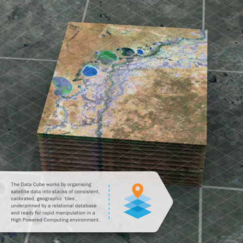
- exploration of open source platforms – such as the Open Data Cube – for removal of data handling and analysis complexity; the Open Data Cube provides a collaborative infrastructure for many possible users and uses; basic handling, calibration and processing of the EO satellite data are undertaken in a standardised way – once – and made openly available for the benefit of all prospective users and all prospective data providers;
- closer attention to understanding of user needs and obstacles.
Such strategies must include reflection on the needs of the SDG stakeholders, including the NSOs, if the requirements of countries reporting against the Global Indicator Framework are to be properly addressed.
Figure 1: The Open Data Cube
5.4 Data continuity
National mapping and statistical agencies recognise the potential for new types of datasets to revolutionise their ability to assess and track a broad range of indicators for their countries. But they must take a suitably conservative view when planning the evolution of their systems and processes to ingest and integrate such new data. These agencies need confidence that there will be continuity over years and decades for any new data streams before making investments in new systems. This requires satellite EO data providers to provide clarity as to the outlook for continuity in their planning for replacement of satellite missions.
Analysis shows that the average lifetime for governmental EO satellite missions is increasing – now around 7 years – thanks to advances in technology and experience in operations. At the same time, space agencies have recognised the need for confidence in data supply to stimulate investment by users in exploitation of the data stream. Much like the planning for safety-critical weather satellites to ensure uninterrupted data supply, we are seeing more EO satellite programmes designed to ensure redundancy through parallel/overlapping operation of identical satellites and funding of mission series far into the future. The US Landsat programme has provided 45 years of continuous land surface imaging since 1972. In Europe, the Sentinel series of optical, radar, ocean and atmosphere sensors foresee continuous data supply for a range of measurements through to 2030 and beyond through the Copernicus Programme.
The long-term continuity provided by these programmes enable countries to plan with confidence the integration of their data into national statistical systems for the SDGs and a multitude of other national purposes.
5.5 Leave no one behind
A core commitment of the 2030 Agenda is to support the poorest and most under-represented, ensuring that no one is left behind. Ensuring that this principle is met and translated into effective action requires an accurate understanding of target populations and their vulnerabilities by governments and the international community. This also has profound implications for the global data community, comprised of NSOs, data specialists across Ministries and the Custodian Agencies, as well as the EO and geospatial data community, civil society and the private sector.
Space agencies have agreed to work in cooperation, through CEOS, to continue their resolve to enable more countries to be able to use more satellite data for more of their national challenges. This includes further efforts to provide free and open data and to reduce data access and complexity challenges.
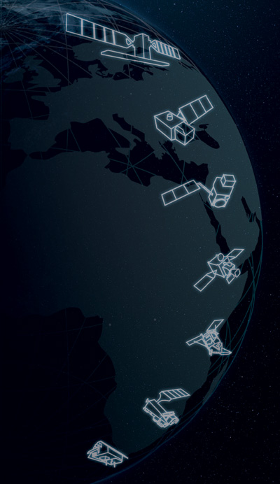
Figure 2: The Sentinel satellite series of the Copernicus Programme is funded to offer continuity out to 2030