A large number of UN bodies and international organisations play active roles in the 2030 Agenda as Custodian Agencies, supporting countries with methodologies and data for monitoring Indicators.
GEO and CEOS provide important coordination of the EO community and are joining their efforts in showcasing the value of, and facilitating access to, EO in support of the full realisation of the 2030 Agenda.
The scope and scale of the SDGs and associated Global Indicator Framework is such that a broad range of stakeholders are involved and effective partnerships among them are fundamental to success in implementing and monitoring progress towards the Goals and Targets. These stakeholders include UN bodies, NSOs and the line Ministries responsible for the different Indicators, suppliers of spatial data infrastructures, as well as data providers and the international bodies that coordinate them.
4.1 UN institutions
Multiple UN institutions are involved in the implementation and monitoring of the SDGs.
The UN Statistical Commission (UNSC) is a functional commission of the UN Economic and Social Council (ECOSOC) and is supported by the UN Statistics Division, which is the central mechanism within the UN to supply global statistics. UNSC brings together chief statisticians from member states from around the world. UNSC has the mandate to oversee the development of the Global Indicator Framework for the SDGs.
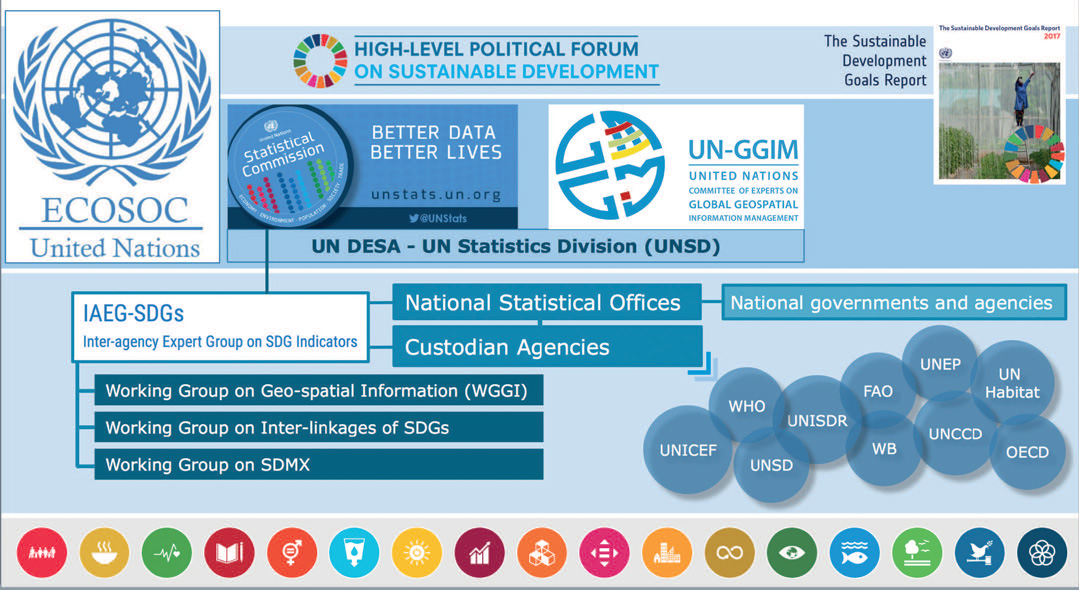
Figure 1 highlights the important role of the various Expert and Working Groups that have been established within the UN system to define the Global Indicator Framework and to address fundamental issues such as the role of geospatial information and its integration with national statistics.
The Inter-Agency Expert Group on SDG Indicators (IAEG-SDGs, established in March 2015) is comprised of representatives of national statistics offices and is in charge of developing and implementing the Global Indicator Framework.
The UN Committee of Experts on Global Geospatial Information Management (UN-GGIM, established in July 2011) is another important player within the UN governance system on SDGs, and leads in the role of developing understanding and application of geospatial information for the monitoring of the Goals and Targets of the 2030 Agenda. UN-GGIM coordinates the specialist Working Group on Geospatial Information (WGGI, established in March 2016), which looks at the Indicator Framework through a “geographic location” lens to identify existing geospatial data gaps and methodological issues and to consider how geospatial information and EO can contribute to its viability. The establishment of the WGGI acknowledges the demand from the 2030 Agenda on Sustainable Development for new data acquisition and integration approaches that can improve the availability, quality, timeliness and disaggregation of data, and consequently support the implementation of the SDGs at all levels.
As explained in Section 2, the UN has appointed specialised agencies (UN agencies and international organisations) to play a coordinating role as Custodians of SDG Indicators relevant to their area of expertise or mandate. These Custodian Agencies have the mission to compile monitoring guidelines for measuring and reporting on the indicators, to support countries on their implementation and strengthen national statistical capacities, and to collect national data for the global reporting mechanism.
Finally, progress towards the Goals are reported and reviewed annually through to 2030 within the UN’s High-Level Political Forum (HLPF) on Sustainable Development.
Figure 1: UN governance system for the development and implementation of the Global Indicator Framework on SDGs.
4.2 National statistical and geospatial institutions
The Indicators are the benchmarks for the monitoring and reporting by national governments of their progress towards the SDGs. NSOs, in collaboration with the relevant UN Custodian Agencies as appropriate, will report against these indicators to the UN Statistics Division for compilation into the Sustainable Development Goals Reports.
Given the fundamental role of geospatial information and EO to the viability of many of the Indicators, there is a substantial role within countries for those agencies responsible for geospatial information, national information systems and national spatial data infrastructures.
It is recognised that for many developing countries, there remains a significant capacity challenge around the access, processing, analysis and production of the necessary data. The translation of geospatial data into information for decisions and reporting on their international engagements, such as on their progress towards the SDGs, will also require significant investment. Bodies such as UN-GGIM with the support of their Regional Committees aim to assist national geospatial information agencies with the relevant geospatial standards, with data and information interoperability and with the integration of statistical and geospatial information.
The hope is that the 2030 Agenda will serve as a catalyst for accelerated development of national spatial data infrastructures and provide a unique opportunity to the geospatial communities to integrate geospatial information into the Agenda and national statistics more broadly.
4.3 EO data and information providers and their coordinating bodies
The success of the 2030 Agenda will depend on the availability of high quality, timely and universally accessible data. The effective use of EO data in support of national monitoring and reporting against the Global Indicator Framework, as well as informed decision making on development policies, will require closer collaboration among national statistical offices and the EO data providers and communities.
GEO
GEO and UN-GGIM have started to work closely with the statistical community, at both national and global levels, to provide inputs into the processes to implement the Global Indicator Framework.
In its role coordinating international efforts to build a Global Earth Observation System of Systems (GEOSS) that better integrates observing systems and shares data, GEO plays an instrumental role in promoting and showcasing the value of EO in support of the SDGs. More than 100 governments and 100 participating organisations collaborate on the GEOSS to better integrate observing systems and share data by connecting existing infrastructures using common standards.
GEO is a unique global network connecting government institutions, academic and research institutions, data providers, businesses, engineers, scientists and experts to create innovative solutions to global challenges at a time of exponential data growth, human development and climate change that transcend national and disciplinary boundaries. The unprecedented global collaboration of experts helps identify gaps and reduce duplication in the areas of sustainable development and sound environmental management.
GEO and the GEOSS incorporate EO from diverse sources, including satellite, airborne, in-situ platforms and citizen observatories. There are more than 400 million open data resources in GEOSS from more than 150 international providers such as national and regional space agencies, international organisations such as the World Meteorological Organization (WMO) and commercial satellite data providers.
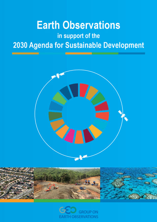
Figure 3: GEO Booklet “Earth Observations in Support of the 2030 Agenda for Sustainable Development”
In 2015, GEO launched a new initiative called, ‘EO for Sustainable Development in Service of the 2030 Agenda (EO4SDG)’. EO4SDG seeks to realise and expand the potential of EO to advance the 2030 Agenda and enable societal benefits through achievement of the SDGs. One of the contributed articles in Part II of this Handbook focuses on EO4SDG and provides further detail on the activities of this GEO initiative.
In brief, EO4SDG has four implementation mechanisms, some in partnership with custodian agencies, some in partnership with NSOs:
- national pilot projects integrating EO with national statistical data;
- capacity building around development and implementation of methodologies to apply EO data;
- identification and development of data and information products to advance understanding and access to suitable EO resources;
- outreach and engagement activities.
GEO’s efforts on the SDGs prioritise Goals and Targets where GEO has strong and active communities with adequate resources and potential to deliver tangible outcomes within the 2017–2019 timeframe, namely:
- SDG 2: zero hunger;
- SDG 6: clean water & sanitation;
- SDG 11: sustainable cities and communities;
- SDG 13: climate action;
- SDG 14: life below water; and
- SDG 15: life on land.
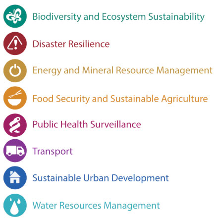
Figure 4: The GEOSS serves a broad range of societal benefit areas of relevance to the SDGs
As well as coordination with many UN agencies and international organisations involved in the development of the SDG Global Indicator Framework, GEO efforts connect to other key SDG stakeholders such as the Sustainable Development Solutions Network (SDSN), the Global Partnership for Sustainable Development Data (GPSDD) and the International Institute for Sustainable Development (IISD).
CEOS
CEOS is the Committee on Earth Observation Satellites, created in 1984 under the aegis of the G7 Economic Summit of Industrialised Nations Working Group on Growth, Technology and Employment.
CEOS was established to provide coordination of the Earth observations provided by satellite missions, recognising that no single programme, agency or nation can hope to satisfy all of the observational requirements that are necessary for improved understanding of the Earth system. Since its establishment, CEOS has provided a broad framework for international coordination on space-borne EO missions.
CEOS has three primary objectives:
− to optimise the benefits of space-based EO through cooperation of CEOS Agencies in mission planning and in the development of compatible data products, formats, services, applications and policies;
− to aid both CEOS Agencies and the international user community by, among other things, serving as the focal point for international coordination of space-based EO activities, including GEO and entities related to global change;
− to exchange policy and technical information to encourage complementarity and compatibility among space-based EO systems currently in service or development, and the data received from them, as well as address issues of common interest across the spectrum of EO satellite missions.
CEOS membership has reached 34 space agency Members in 2018, comprising almost all of the world’s civil agencies responsible for EO satellite programmes.
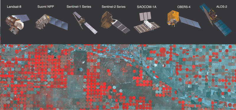
CEOS is formally recognised as the ‘space arm’ of GEO and has strong links to the GEO community at many levels. CEOS engages directly with specific GEO initiatives to understand how existing and future assets can be optimised to meet specific user needs. CEOS also develops and operates ‘virtual constellations’ (see Figure 3) that promote continuity of observations for a particular variable (e.g., sea surface temperature), coordinating mission development and operations across space agencies from around the world.
Recognising the fundamental role for satellite EO in the realisation of the Global Indicator Framework, CEOS has identified the SDGs as a top priority and established in October 2016 the CEOS Ad-Hoc Team on SDGs (AHT SDG) dedicated to better coordination of the world’s space agencies in support of the provision of satellite data for the 2030 Agenda, in full alignment with the activities of the GEO EO4SDG initiative. An early outcome in cooperation with GEO has been the production of the booklet ‘Earth Observations in support of the 2030 Agenda for Sustainable Development’. This report highlights the potential role of satellite observations to support the Global Indicator Framework; a link to the report is provided below.
Through its AHT SDG, CEOS works on behalf of, and in coordination with, the world’s civil space agencies to advocate for and promote measures to progress acceptance and uptake of satellite observations in the 2030 Sustainable Development Agenda. CEOS plans, developed in coordination with GEO/EO4SDG, include:
− showcasing and promoting the contribution of satellite EO to the SDG Targets and Indicators;
− development of a forum for sharing and communicating EO best practices in support of the SDGs;
− engagement with relevant SDG stakeholders inside the UN system (e.g. UNSD, UN-GGIM, IAEG-SDGs, WGGI, Custodian Agencies) and outside the UN system (e.g. GPSDD, IISD, World Bank);
− use of CEOS agency assets to build EO capacity at all levels of the SDG implementation.
Figure 3: CEOS Virtual Constellations coordinate the investments of space agencies around the world to address specific challenges. This example shows the missions supporting food security and forest management