Hyperspectral Imagers
Description
Hyperspectral imagers simultaneously acquire radiance measurements in many narrow, contiguous spectral bands, and the field is often referred to as ‘imaging spectroscopy’. Whereas multispectral scanners measure radiance in a small number of relatively broad wavelength bands (typically less than ten), hyperspectral imagers collect measurements in a much larger number of bands (up to hundreds) focused on adjacent, narrowly defined regions (typically less than 10 nm) in the electromagnetic spectrum.
Hyperspectral imagery is a relatively new type of Earth observation data and its utility is still being assessed in many application areas. It has the potential to allow greater understanding of vegetation dynamics and physiology and will also help to determine the most discriminating spectral bands for particular target materials and/or conditions. To date, space-based hyperspectral imagers have focused on the visible- to shortwave infrared range; however - useful applications may also be possible in the thermal infrared range.
Information from the first generation of space-based hyperspectral imagers is also valuable for designing future sensors, correcting atmospheric and illumination effects in other imagery, determining optimum timing (in the diurnal and/or seasonal cycle) for target discrimination, and/or calibrating data from other Earth observation sensors. Typical spatial resolution for hyperspectral imagers is 30 m, and the intensive spectral sampling required generates significant data volumes, which introduces significant strains on downlink and the data handling and processing infrastructure.
While a gradual move from multispectral to hyperspectral imagery could be envisaged, significant developmental and scientific challenges remain to unlock the significant potential of this technology.
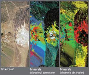
Mineral mapping by AVIRIS airborne hyperspectral imager.
|
 |
| |
|
|
| Current & planned instruments |
| HISUI |
|
Hyperion |
|
|
| HSI |
Visible imaging spectrometer (HyspIRI) |
|
|
| HYC |
|
|
|
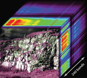
Representation of a typical hyperspectral ‘data cube’.
Applications
The highly resolved image radiance measurements collected by hyperspectral imagers allow continuous spectra to be derived for target features. The resulting spectra can then be compared with field and/or laboratory spectra to identify surface materials. This has proven particularly valuable for mapping minerals and soils, vegetation species, composition and health, shallow coastal and coral reef habitats, and water quality. Hyperspectral imagery is typically used to acquire intensive measurements over research sites that are subsequently extrapolated to larger areas using other datasets, though some applications do use regional or broader coverage, and repeat imagery is often required to monitor changes.
For some application areas, the value of hyperspectral imagery is focused on specific spectral regions, such as:
− Thermal infrared for soil moisture research;
− Visible to shortwave infrared for vegetation mapping;
− Middle infrared plus thermal infrared for mapping minerals and soils; and
− Visible to near infrared for shallow coastal and coral reef bathymetry, and benthic cover mapping.
The fusion of hyperspectral imagery with imaging microwave radar (SAR) data is valued for defence applications, and for improving the separation of fractional cover components in evergreen vegetation.
|
|