Cloud Profile and Rain Radars
Description
Cloud profile radars use very short wavelength (mm) radar (typically 94 GHz) to detect scattering from non-precipitating cloud droplets or ice particles, thereby yielding information on cloud characteristics such as moisture content and base height.
A 94 GHz cloud profiling radar has the unique property of being able to penetrate ice clouds with negligible attenuation and providing a range-gated profile of cloud characteristics.
Rain radars use microwave radiation (centimetre wavelengths) to detect backscatter from water drops and ice particles in precipitating clouds, and to measure the vertical profile of such particles. One of the key challenges with such radars is suppressing the return from Earth’s surface (ground clutter), which is inevitably much stronger than the rain echo. Recent instruments however, can map the 3D distribution of precipitating water and ice in a relatively narrow swath (around 200 km) along the track of a low-altitude satellite, making it possible to infer more precise estimates of instantaneous rainfall.
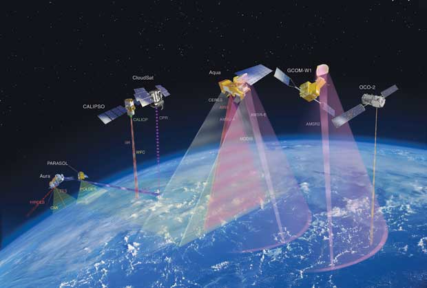
The Precipitation Radar (PR) on the Tropical Rainfall Measuring Mission, launched in 1997, was the first radar in space with the capability to measure rainfall. PR provided 3D maps of storm structure and invaluable information on the intensity and distribution of rain, rain type and storm depth. NASA’s CloudSat uses an advanced 94 GHz radar to ‘slice’ through clouds to see their vertical structure, providing a completely new observational capability from space. These instruments are the first to study cloud profiles on a global basis, and to look at their structure, composition and effects. From early 2014, the Global Precipitation Measurement mission – an international cooperative programme – will provide more frequent and complete sampling of Earth’s precipitation using a constellation of satellites. As of 2016, the Japanese instrument on the ESA–JAXA EarthCARE mission, the 94 GHz CPR, will continue providing cloud profile observations, with increased sensitivity and additional Doppler capability to observe vertical motion.
Applications
Measurements from cloud radar give information on cloud type and amount, and, more importantly, on cloud profile (currently not measured). This information is required both for improving numerical weather prediction and for climate studies. Scientists believe that some of the main uncertainties in climate model simulations are due to the difficulties in adequately representing clouds and their radiative properties. Satellite observations have now started to address this issue.
|
 |
| |
|
|
| Current & planned instruments |
| Cloud radar (ACE) |
|
DPR |
|
|
| CPR (CloudSat) |
PR |
|
|
| CPR (EarthCARE) |
|
|
|
TRMM has demonstrated that spaceborne rain radars can provide a unique source of information on liquid water and precipitation rate, since the ground-based rain radars used at present have limited coverage over the oceans. The global precipitation datasets derived from TRMM have proved to be valuable tools for climatologists. Information on tropical rainfall and extreme events such as hurricanes is of particular importance, since more than two thirds of global rainfall is in the Tropics, acting as a primary driver of global atmospheric circulation.
The potential gap between termination of the TRMM mission (currently operating well beyond its planned lifetime) and availability of the new information anticipated from GPM (no earlier than 2014) is of concern to scientists studying Earth’s global water cycle. CEOS has initiated a precipitation virtual constellation study team to address this and related coordination issues.
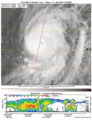
Hurricane Julia (2010) AMSR-E microwave data (top), with
CloudSat reflectivity data (bottom) profiles clouds through the eye of
the storm.
(Click image to view full size)
|
|