An International Framework for Climate Monitoring from Space
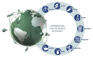
The Contribution of Essential Climate Variables to Climate and Other GEOSS Societal Benefit Areas
The role that satellites play in observing Earth’s climate variability and change has increased substantially in recent decades. Significant progress has been made in observing Earth in time and space which, before the advent of satellites, was all but impossible. Satellite observations allow us to construct global views of variables that characterise Earth’s land, oceans and atmosphere, such as cloudiness, ice-sheet extent, sea-surface temperature and vegetation cover. With some satellite observations now spanning more than 40 years, their potential for climate monitoring purposes has become increasingly evident. Yet, a robust international framework to realise and sustain this potential does not exist.
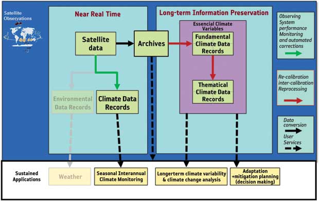
Figure 1. Conceptual architecture of the Global Earth Observation System of Systems.
(Click image to view full size)
Many satellite sensors, systems and policies were either not designed for climate purposes, or were not intended to operate over the long time frames needed for climate assessments. To support weather prediction, many space agencies have instituted contingency agreements to ensure continuous access to observations. This is not yet the case for climate applications. Further, despite recent progress, data-sharing policies and practices remain less robust for climate data than for weather data.
Clearly, there are international, as well as national, policy mandates or structures regarding climate and climate change. In 1988, the Intergovernmental Panel on Climate Change was established by the United Nations Environment Programme and the World Meteorological Organization. Its charter is to review and provide recommendations to governments regarding the state of knowledge of climate change science, the risks associated with human-induced climate change, the social and economic impacts of climate change and possible response strategies. In 1992, the United Nations Framework Convention on Climate Change – an international environmental treaty – was established to consider actions for reducing global warming. Nationally, reports like the United Kingdom’s 2006 Stern Review and the United States’ 2007 Decadal Survey have also contributed to an increased awareness among policy makers of climate change and monitoring.
The IPCC’s 2007 4th Assessment Report underscores the urgent need for climate-observing capabilities, and an international architecture supporting them, to monitor the global water cycle and the global carbon cycle. Key private sector stakeholders include major industries, such as insurance, agriculture, energy and transportation, who have increasingly called for authoritative climate reference data upon which to base investments and strategic plans. Climate data are also required to better observe and predict trends in climate extremes, such as drought, floods, tropical cyclones and coastal hazards. Improved knowledge in these areas translates into lives saved and property protected, improved economic resiliency, improved security and well-being of the public.
What Are Essential Climate Variables?
The Global Climate Observing System identified a set of geophysical variable types, or Essential Climate Variables, that are associated with climate variation and change. The ECVs, such as cloud properties, sea state and snow cover, are grouped into three categories: atmospheric, terrestrial and oceanic.
An ECV typically encompasses several geophysical variables that characterise it. For example, the cloud properties ECV includes descriptors of cloud type, height, thickness and composition. If a climate signal exists in measurements of these variables, it typically is small but persists over long time periods (seasonal, interannual, and decadal to centennial). This stands in contrast to the often large, but short-term, changes associated with weather. Thus, to detect trends unambiguously, climate data products must meet more rigorous criteria than many other applications. The US National Academies term such products Climate Data Records (CDRs), defined as time series of measurements that are of sufficient length, consistency and continuity to determine climate variability and change.
Two categories of CDRs exist based on data content: Fundamental Climate Data Records (FCDRs) and Thematic Climate Data Records (TCDRs). An FCDR denotes a consistently calibrated sensor data record that describes the energy observed in space. Because instruments continuously degrade in orbit, FCDRs typically require data from a succession of sensors, including sensors of different designs. Scientists create unified and coherent FCDRs by scientifically adjusting for sensor changes. A TCDR denotes a geophysical variable, such as cloudiness or ice-sheet extent, that is derived from an FCDR. It is closely connected to the ECVs, but strictly covers exactly one variable.
Figure 2. The wide range of sustained
applications that can be addressed using Essential Climate Variables
derived from a suite of Climate Data Records.
What Constitutes a Climate Data Record?
Climate monitoring principles, requirements and guidelines for the creation of CDRs have been formulated to increase awareness within space agencies to the specific observational and procedural needs for establishing a successful climate monitoring approach. A complete characterisation of Earth’s climate systems requires observations of the ocean, land, cryosphere and atmosphere and the coupling between these systems.
Climate monitoring requires near-continuous observations, references to a common standard, over at least several decades and, ultimately, to a century or more. This is why an efficient climate monitoring architecture needs to be formulated and sustained.
Earth’s climate changes slowly relative to the period over which any individual satellite lasts. Hence, monitoring the climate system is difficult unless a whole-system view is taken. Most current CDRs are based mainly on data from satellite systems primarily built to support short-term weather and environmental prediction applications. These records are often extended backward in time by combining them with historic ground-based in situ data, such as surface air temperature measurements. Thus, past weather and Earth observations, from both in situ and space-based sensors, have left an enormous legacy of data that provides the basis of our current knowledge on climate variability and change.
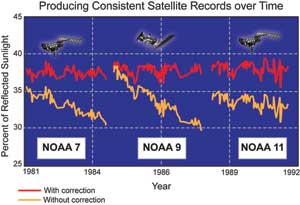
Nevertheless, many peculiarities associated with the satellite data must be addressed to meet climate requirements. Depending on the sensor, these may include challenges in instrument calibration, limited traceability to standards, underdetermined error budgets and changes in the observation time-of-day. These issues can introduce artefacts into long-term time series and require careful attention to produce quality climate products. Figure 3 illustrates how climate scientists correct calibration drifts across three different instruments (without correction) into a consistent climate data record over the long term (with correction).
Figure 3. Original time series of reflected sunlight from the land surface (without correction) are transformed into
Climate Data Records (with correction) using stable ground targets.
In addition, weather observations do not address all climate observing needs, e.g., the observation of greenhouse gas variability has negligible importance for weather but is critical for climate monitoring. The same is true for many land and ocean biosphere observations. GCOS has developed Climate Monitoring Principles that set out a general guideline to achieve observations with the required quality. The monitoring principles address key satellite-specific operational issues. These include the availability of high-quality in situ data for calibration and validation of the satellite instruments. The most relevant and comprehensive set of CDR requirements is provided in Systematic Observation Requirements for Satellite-Based Products for Climate, a supplement to the GCOS Implementation Plan applicable to climate change and long-term variability monitoring. The GCOS requirements are given for a subset of the ECV where the feasibility of satellite measurements has been demonstrated. Although this ECV subset currently does not reflect all important climate variables, it evolves with each update of the GCOS supplement. Increasingly, agencies as well as international initiatives are adapting to these requirements. In some cases, this has been done in a coordinated manner through CEOS, based on a specific request arising from UNFCCC.
Additionally, the scientific community has requirements that evolve around specific thematic interests, such as changes in weather extremes or the Greenland ice sheet, that arise independent of mission planning but can have a significant influence on future mission planning. Such requirements are slowly integrated into the GCOS Implementation Plan and updates of the Satellite Supplements. However, space agencies need to consider the observing needs of the community independently of the GCOS process even when it is not in phase with mission planning.
International Coordination Efforts to Produce Climate Data Records
Although the field of climatology has ancient roots, the mixture of global change with climate has led to the emergence of the new field of geophysics: climate and global change. This field has only emerged in the last 20 years or so, however it is time now to review and capture the best business practices that have evolved. One of the greatest challenges in this effort stems from the large number of disciplines involved, spanning the wide range of geophysics, computer science and information preservation. In order to move forward, a ‘lingua franca’, or common language or understanding, must be developed as the challenge requires a concerted international effort.
Space agencies have established steps, procedures and guidelines for the evolution of mature research data records into a sustaining production context, based on recommendations from expert bodies such as the US National Academy of Sciences and GCOS.
Such practices are being described and shared through coordination bodies such as the Working Group on Climate within the Committee on Earth Observing Satellites (WGClimate CEOS). WGClimate leads the CEOS effort to provide a coordination mechanism amongst space agencies to use Earth observations to monitor and understand climate variability and change.
To ensure success, WGClimate is engaged in defining a framework, known as an architecture. In building structures, the term ‘architecture’ refers to the process of planning, designing and construction.
This term has been adopted by the information technology community to refer to the design of a system. In this case, it applies to the information technology system required for climate information stewardship, consisting of data collection, data quality, archiving, processing, reprocessing, discovery and access for climate data records.
A Vision for a Sustained Observation System for Climate Monitoring from Space
This vision of a sustained observation system for climate monitoring can be expressed by its intended usage. To date, three main usage scenarios have been identified:
- To promote a common understanding amongst the various stakeholders for meeting the various climate monitoring requirements;
- To assist in the assessment of the degree to which the current and planned observing systems meet the climate monitoring requirements;
- To gain an appreciation of the information flows and dependencies of the end-to-end processes (i.e. from sensing right through to decision-making).
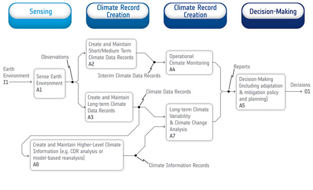
Two graphical views can be used to describe the architecture: a logical view describing the required data flows and functions, and a physical view describing the implementation characteristics.
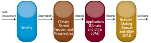
Figure 4. Logical view of a climate architecture.
(Click image to view full size)
In this end-to-end logical view, the information flow starts with the satellite sensing of the Earth environment. The resultant observations are then assembled, processed and converted to climate records. These records are then used by the relevant applications to generate reports, which are, in turn, used by decision-makers (including policy-makers) to determine a course of action. The observation system for climate monitoring is limited to the first two pillars and, as illustrated in the following diagram for the second pillar, it is possible to ‘drill down’ within each of the pillars in order to expose their constituent functions and data flows.
Whilst the logical view is generic in that it applies to all ECVs, in order to facilitate the assessment of the implementation status for each ECV, the physical view has an ECV-specific focus and typically consists of three types of information:
• ECV-specific Requirements;
• Current Implementation Status for each ECV;
• Planned (but not yet implemented) Contributions for each ECV.
Thus, the physical architecture will allow CEOS Agencies to coordinate their climate observation, processing, archival and access functions to ensure they meet societal requirements.
in 2014, the database of ECVs will be integrated with the CEOS Database of Missions, Instruments and Measurements.
The ESA Climate Change Initiative: Satellite Data Records for Essential Climate Variables
The Climate Change Initiative (CCI) was set up by the European Space Agency as a response to the UNFCCC’s need for systematic observations and data archive development related to improving understanding of the climate system. The principal objective of the programme is to realise the full potential of the long-term global Earth observation archives that ESA has established over the last 30 years, as a significant contribution to the Essential Climate Variable databases required by GCOS.
It will therefore contribute to the international CEOS response to the Global Climate Observing System and is expected to underpin the establishment of a climate service under the European Global Monitoring for Environment and Security initiative.
CCI complements existing efforts in Europe (e.g., those led by EUMETSAT) and internationally (e.g., under the umbrella of SCOPE-CM). The success of the programme will be measured by the quality of its satellite-based ECV products, the impact the products have in the climate change community (such as in the IPCC reports) and its ability to establish lasting and transparent access to these results. CCI is dedicated to the systematic generation of fully described, error-characterised and consistent satellite-based ECV products.
Each ECV project team brings together a diverse set of people from a range of institutions, fronted by a science leader. Each team is designed to contain three groups of expertise, an Earth observation group, a system engineering group and a climate research group. To ensure full engagement with the climate modelling community, an additional project was established; the Climate Modelling Users Group provides a forum for feedback and discussion between modellers and observation scientists. This group is intended to ensure the maximum utility of the products produced by CCI.
— The lifetime of the programme is divided into three phases; In the first, innovative approaches for continuous generation of ECVs are being defined and validated, so the products can be specified and prototyped. The second phase will develop the operational systems to be put in place for ECV production, bringing together the relevant science communities with industry and data centres in Europe. The final stage will provide a framework for comprehensive feedback from the climate community and guidance on future evolution of ECV production.
— Throughout the programme, best-practice examples are followed, all processes are well-documented and made as transparent as possible and, at all stages, time is allowed for feedback, iterations and consultation with a wider community of users and experts.
— Cross-cutting activities across the wide range of project topics provide valuable, high-level discussions on data standards and harmonisation, data quality, data access, etc. The programme also provides an opportunity to exploit the benefits of interdisciplinary teams to tackle new science questions arising from the ECV products and, thus, develop a well-connected, Earth observation science community.
Figure 5. A breakdown of the physical
architecture which allows CEOS agencies to
coordinate resources for addressing climate and
other societal benefit areas.
ESA's Climate Change Initiative has a number of ECV projects in support of the climate architecture.