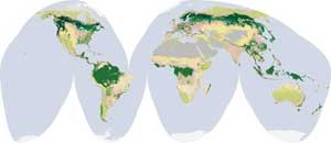
Forests cover around 30% of Earth’s landmass. They provide a wide variety of ecosystem services: cooling and moistening our air, filling it with oxygen; sheltering countless species from the wind, Sun and elements; anchoring the soil; and playing a pivotal role in the Water Cycle. They are vital to many human activities: providing food, fuel, medicines and building materials; acting as a nurturing home and cultural anchor for many indigenous peoples; and driving industry and the economy in many parts of the world.
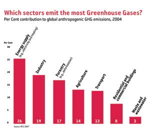
In addition to their essential role in life on Earth, forests help to balance Earth’s carbon budget. Over 60% of greenhouse gasses are emitted by three economic sectors, with forestry the third largest at 17% [UNEP, From Rio to Rio+20].
Global forest cover.
Greenhouse gas emissions of human origin by sector.
(Click images to view full size)
Deforestation and Implications
There are many causes of forest degradation, including poor management practices in production forests, fires, overgrazing, overharvesting of fuelwood and other non-wood products, illegal cutting of timber, and pest and disease outbreaks. In many developing countries, deforestation, forest degradation, forest fires and slash and burn practices make up the majority of carbon dioxide emissions.
Deforestation and forest degradation also have severe adverse impacts on forest biodiversity and the availability of forest products, soil resources, water resources and local livelihoods, and often remove an important safety net for the rural poor.
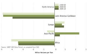
Earth’s forested area has decreased by 300 million hectares since 1990, or an area larger then Argentina [UNEP, From Rio to Rio+20]. Planting of new forests and the natural expansion of forests in some countries have resulted in a decrease in the net loss of forests. Yet we are still losing about 20000 hectares of forest each day, or an area more than twice the size of Manhattan (UN REDD Framework Development).
Forest net change since 1990.
(Click image to view full size)
At present, only about 10% of global forests are under certified sustainable management (UNEP, From Rio to Rio+20). In an effort to improve the sustainability of forest management practices around the world, a number of global initiatives are being coordinated. These are intended to promote the development of national forest information systems, and are underpinned by the availability of products derived from satellite remote sensing.
Rio Forest Principles and the REDD+ Framework
The Rio Earth Summit in 1992 agreed on a set of forest principles (the Rio Forest Principles), which represent the first global consensus on forests. The principles state that forests, with their complex ecological processes, are essential to economic development and the maintenance of all forms of life. The guiding objective is to contribute to the management, conservation and sustainable development of forests and to provide for their multiple and complementary functions and uses. The Principles include:
− A country’s right to use forests for their social and economic development needs. Such use should be based on national policies consistent with sustainable development.
− Sustainable use of forests will require sustainable patterns of production and consumption at a global level.
− International financial support, including some from the private sector, should be provided to developing nations to help protect their forests.
− Forestry plans should count both the economic and non-economic values of forests, and the environmental costs and benefits of harvesting or protecting forests. Policies that encourage forest degradation should be avoided.
Another key product of the Rio Earth Summit declaration was the UN Framework Convention on Climate Change. The countries who signed the UNFCCC agreed to meet at COP (Conference of the Parties) meetings on an annual basis. The third COP meeting (COP-3) took place in Kyoto, Japan in 1997, where the member countries prepared the Kyoto Protocol. Article 3.3 of the Kyoto Protocol requires countries to account for forest carbon management, introducing what is known as ARD: Afforestation/Reforestation/Deforestation. This, however, only applied to developed (Annex I) countries and did not include credits for conservation of forests (carbon stocks).
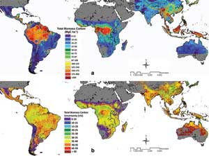
Benchmark map of carbon stored in Earth’s tropical forests, (top) and a map showing the corresponding uncertainties in the estimates (bottom). Derived from a combination of MODIS, ICESat, QuikScat
and SRTM data.
(Click image to view full size)
Discussions on how to bring both developing countries and protection of carbon stocks into the negotiations eventually lead to the decision adopted by the UNFCCC at COP-13 in 2007 on Reducing Emissions from Deforestation and Forest Degradation. The UN recognises that the implementation of a REDD programme is a huge undertaking, and for this reason it is working closely with the World Bank's Forest Carbon Partnership Facility (FCPF) and the Global Environment Facility (GEF Tropical Forest Account). Within the UN, three agencies are directly involved: the UN Food and Agricultural Organization; the UN Environment Programme; and, the UN Development Programme (UNDP). REDD is also supported by partnership and capacity-building programmes, such as Australia's International Forest Carbon Initiative. It was recognised that reducing deforestation has other benefits, and so REDD was eventually expanded to encompass activities such as the sustainable management of forests, protecting biodiversity and the enhancement of forest carbon stocks, and is now referred to as REDD+.
Policy Challenges
There are four key policy framework concerns that need to be addressed in order to gain international agreement on reducing emissions from deforestation.
Leakage: the potential for a climate mitigation project in one area to displace activity to another area, rather than abate emissions.
Additionality: that a mitigation project will have effect beyond projections of business-as-usual baselines, and/or it is an activity that would not be otherwise economically viable.
Baselines: time-series consistent monitoring and archival data to provide a baseline of historical trends.
Permanence: the persistence of emission reductions made in forest carbon projects (i.e. supported by time-series and spatially consistent forest monitoring).
Although the treatment of forests in global climate change agreements has been hindered in the past by limited capacity to measure and monitor, this situation is changing. Earth-observing satellites and their data systems have advanced to the point where they can provide ‘wall-to-wall’ remote sensing of forest and other vegetation cover, and modelling techniques have evolved, allowing extrapolation from ground-based forest measurements.
FAO Global Forest Resources Assessment Remote Sensing Survey
Every five years, UN-FAO releases a global forest resources assessment (FRA) based on (non-spatial) forest information provided by its member countries. Since 2008 FAO, along with the EC Joint Research Centre and other partners, have also undertaken a parallel global survey of forests based on satellite remote sensing techniques linked to the FRA. The remote sensing survey aims to improve the knowledge on forest land use change dynamics over time, including deforestation, afforestation and natural expansion of forests. It employs a systematic sampling strategy, with 10 sq-km sample sites located at each latitude–longitude intersection. This provides a sample intensity of about 1% of the global land surface, from which statistical methods are used to generate national and global estimates. These sample plots are also used for the national forest assessments supported by FAO and by many national forest inventory programmes.
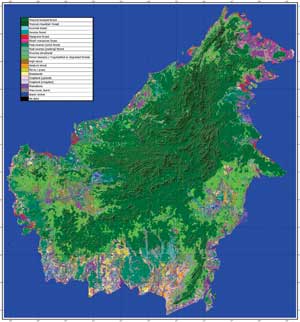
Land Cover Classification over Borneo using single-year coverage of ALOS PALSAR.
(Click image to view full size)
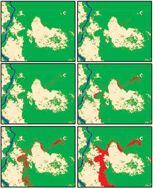
Rapid deforestation detection in Central Kalimantan using bi monthly time-series of Envisat ASAR.
The data used for the assessment are sourced from the Landsat series, and make use of the best available images acquired as close as possible to the target years of 1990, 2000 and 2005 over the sample sites. Landsat imagery was used as the primary source of data because of its global coverage, long time series, spectral characteristics, and 30 m spatial resolution, which make it suitable for detecting tree cover and change in tree cover over time within each sample area. Automated, supervised change-detection approaches are employed, which enables the detection of changes over areas of five hectares or greater in size. The products generated over the sample areas by the automated process are reviewed by national experts to refine the results, and to help build capacity by introducing new remote sensing tools in countries where remote sensing methods are not well developed.
GEO Forest Carbon Tracking
GEO initiated the Forest Carbon Tracking (FCT) Task in 2008, under the leadership of Australia, Norway, Japan, Canada, UN-FAO and CEOS. The Task is a demonstration activity, supporting countries on the path towards the establishment of sovereign national Measurement Reporting and Verification (MRV) systems that comply with IPCC guidelines, and that support REDD+ and other emissions mitigation programs. It aims to demonstrate the feasibility and readiness of Earth observation technology as a reliable means to provide forest information at fine resolution over national and sub-national scales, and in a timely manner. The FCT Task is complementary to the FRA in that it aims to enable forest monitoring on an annual basis, rather than every five years, and that it is based on the use of ‘wall-to-wall’ satellite data to provide spatially specific national-scale forest maps, which are required to support REDD+.
An important component of the FCT Task is the development and the testing of step-by-step methods and protocols from satellite acquisitions to final information products, including methodology guidance protocols for ground data collection, forest information product generation and validation and integration with emission models, which will constitute an important component of national MRV systems. This is being undertaken in collaboration with the governments of 11 National Demonstrators.
The Role of Earth Observation Satellites
The requirement for annual spatially explicit national mapping means the availability of repetitive gap-free medium-resolution satellite data from both optical and microwave sensors covering each of the National Demonstrator countries is essential. CEOS, initially through the CEOS Land Surface Imaging Virtual Constellation, is working very closely with the FCT Task to coordinate satellite acquisitions, with strong support by a large number of national space agencies and satellite data providers. The effort has resulted in a comprehensive satellite data acquisition activity that pools capacity, and maximises interoperable and synergetic use of the available satellite systems.
Using the Landsat (optical) and ALOS PALSAR (radar) global acquisition strategies as models, a first coordinated acquisition plan was designed and implemented in 2009 to accommodate the specific requirements for national forest carbon tracking. Coordinated acquisition campaigns have been augmented by Envisat, RADARSAT and a number of other sensors, and have since been undertaken on a semi-annual basis over the National Demonstrator countries.
It should be emphasised that optical and radar satellites are complementary data sources and both types of systems are required to support the Task efficiently. Optical sensors provide a historical archive over the world’s forest areas, which goes back more than 35 years. The spectral characteristics in the optical domain are well known and suited for forest monitoring, although cloud cover constitutes a considerable limitation in the tropical zone. Spaceborne radar systems, on the other hand, have the capacity to acquire data regardless of cloud cover and sunlight, and can therefore be programmed to cover whole nations and continents within a short and well-defined time window. Radar satellites operate at various wavelengths, which are complementary to each other and sensitive to specific features on the ground, including above-ground biomass. With no cloud cover limitation, time series of radar data can feasibly be programmed to provide detailed information about the time, location and extent of changes in the forest cover.
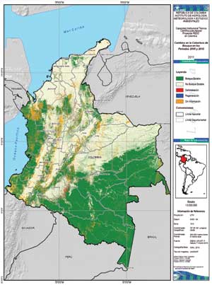
Landsat-based forest cover and change map of Colombia 2005–10.
(Click image to view full size)
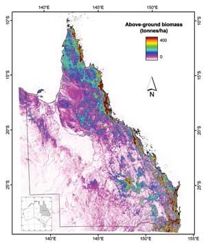
Estimated above ground biomass in northeast Australia, derived from optical (Landsat) and radar (ALOS PALSAR) data.
(Click image to view full size)
The Global Forest Observations Initiative
Building on the concept and experiences of the FCT Task and the associated CEOS satellite data coordination efforts, in November 2011 the GEO Plenary approved the establishment of an operational forest observation programme, the Global Forest Observations Initiative. GFOI takes the national-scale FCT Task to a global level, is open to any country wishing to participate and includes objectives to:
• Foster the sustained availability of observations for national forest monitoring systems and assist countries to make the best use of these observations.
• Support governments in establishing national systems by providing coordinated observations, assistance and guidance on utilising observations, development of methods and protocols, and promoting research and development.
GFOI is promoting national forest information systems by coordinating with national governments that report into international forest assessments, such as UN-FAO’s global FRA, and national greenhouse gas inventories reported to UNFCCC.
Implementing a Global Data Acquisition Strategy
In November 2011, CEOS approved a CEOS data strategy in support of GFOI and FCT Task, which includes three key elements:
• A baseline, coordinated global data acquisition strategy involving a number of ‘core data streams’ that can be used free-of-charge for GFOI purposes.
• A coordinated strategy for national data acquisitions in response to national needs assessments undertaken in the course of GFOI implementation.
• Data supply in support of the ongoing activities in the FCT National Demonstrator countries that continue as supporting research and development projects in support to the GFOI.
These three elements will be combined into the CEOS Global Observation Strategy for Forests, which will support the transition from the national-scale coverage being demonstrated within the FCT Task, to an operational global-scale acquisition strategy under GFOI.
It is hoped that the GFOI will contribute to the development of national forest information systems in support of their management, conservation and sustainable development, helping to ensure their continuing benefit to humankind for generations to come.
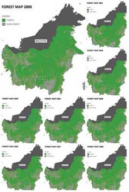
Indonesia’s National Carbon Accounting System (INCAS)
INCAS will provide a comprehensive and credible account of Indonesia’s land-based emissions, supporting Indonesia’s reporting requirements under UNFCCC, and towards a post-2012 climate change agreement. INCAS will also support Indonesia’s entry to carbon markets, and will be the monitoring and information component of a national MRV process, estimating emissions by combining time-series data.
As the rules for REDD+ are developed, INCAS will support Indonesia’s participation by providing:
• wall-to-wall coverage (forest and non-forest estate);
• annual emissions and carbon pools accounts;
• scalability (sub-national to national);
• consistency;
• scenario testing of land use and management options; and
• constant improvement of data and methodologies.
2000-09 forest cover change products for Kalimantan were delivered in November 2011, with products for Sumatra, Papua and Sulawesi expected in 2012. While strong international support has been provided, all products are generated by Indonesian government officials and are subject to INCAS quality assurance standards.