Scatterometers
Description
A scatterometer transmits radar pulses and receives backscattered energy, the intensity of which depends on the roughness and dielectric properties of a particular target. Scatterometers were originally designed to measure oceanic surface winds, where the amount of backscatter depends on two factors – the size of the surface ripples on the ocean, and their orientation with respect to the propagation direction of the pulse of radiation transmitted by the scatterometer. The first is dependent on wind stress, and hence wind speed at the surface, while the second is related to wind direction. As a result, measurements by scatterometers may be used to derive both wind speed and direction.
The main aim of these instruments is to achieve high-accuracy measurements of wind vectors (speed and direction), so resolution is of secondary importance. (They generally produce wind maps with a resolution of order 25–50 km). Because scatterometers operate at microwave wavelengths, the measurements are available irrespective of weather conditions.
Spaceborne scatterometers have provided continuous synoptic microwave coverage of Earth for nearly two decades, starting with the ERS series in 1991, NSCAT on ADEOS, SeaWinds on QuikSCAT, and more recently ASCAT on MetOp. The ERS and NSCAT instruments employed a fan-beam (multi-incidence) wind retrieval technique, whereas QuikSCAT employed a conically scanning (fixed incidence) technique. Increases in swath width capability now mean that a single instrument can provide around 90% coverage of global oceans on a daily basis. The CEOS Ocean Surface Vector Winds Virtual Constellation team is charged with overseeing coordination to ensure adequate continuity of scatterometer measurements by different nations.
Applications
Information from scatterometers provides a unique source of data on sea surface wind speed and direction. This has important applications in weather and wave forecasting, the investigation of climate models and elaboration of marine wind climate. The assimilation of scatterometer data into atmospheric forecasting models greatly improves the description of cyclonic features, which are so important in predicting future weather patterns.
|
 |
| |
|
|
| Current & planned instruments |
| Advanced Scatterometer |
|
Scatterometer (Meteor) |
|
|
| Aquarius L-band Scatterometer |
Scatterometer (Oceansat) |
|
|
| ASCAT |
SeaWinds |
|
|
| SCAT |
WindRAD |
|
|
A large number of new, unforeseen, terrestrial and sea-ice applications have emerged beyond the original ocean winds mission of scatterometers. These include: the measurement of sea-ice extent and concentration; soil moisture; snow accumulation; and regional monitoring of ice shelves, rainforests and deserts. The daily global coverage of scatterometers in the polar regions and their ability to discriminate sea ice, ice sheets and icebergs, despite poor solar illumination and frequent cloud cover, make them excellent instruments for large-scale systematic observations of polar ice.
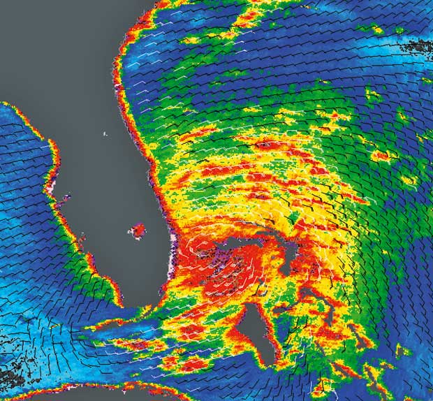
ASCAT wind measurements south of Australia on 19 March 2008.
Superimposed is a 10 m wind field forecast from the European Centre for Medium-Range Weather Forecasts. Darker colours
correspond to areas of low surface wind speeds. Colour tone changes
correspond to changes in the surface wind direction, as the
sensitivity of the measurement from the different antenna beams
varies with the relative direction of the surface wind vector with
respect to the viewing direction of each beam.
|
|