Radar Altimeters
Description
Radar altimeters are active sensors which use the ranging capability of radar to measure the surface topography profile along the satellite track. They provide precise measurements of a satellite’s height above the ocean and, if appropriately designed, over land/ice surfaces by measuring the time interval between the transmission and reception of very short electromagnetic pulses.
To date, most spaceborne radar altimeters have been non-imaging, wide-beam (pulse-limited) systems operating from low orbits. Such altimeters are useful for relatively smooth surfaces such as oceans and low-relief land surfaces, but are less effective over high-relief continental terrain as a result of their large radar footprint (of the order of 25 km).
Jason-2, also known as the Ocean Surface Topography Mission (OSTM), extends the series of satellites that collect global ocean surface data on a continuous basis for several decades. Its aims are to measure the global sea-surface height to an accuracy of a few centimetres every 10 days, and to determine ocean circulation and the mean sea-level trend in support of weather forecasting, climate monitoring and operational oceanography. Launched in June 2008, Jason-2 continues to operate in parallel with the Jason-1 mission. Jason-3 is being developed for launch in the first half of 2014, with the aim of securing the continuity of high-accuracy satellite altimetry observations. The Jason-CS (Continuity of Service) is under study to prolong the Jason series observations well into the 2020s.
Successful exploitation of the height data is dependent upon precise determination of the satellite’s orbit. A number of precision radar altimetry ‘packages’ are available which contain:
— A high-precision radar altimeter (with basic measurement accuracy in the range 2 cm to 4 cm), with dual-frequency capability to correct height measurements from ionospheric delays;
— A means of correcting errors induced in the height measurements by variations in the amount of water vapour along the path (for example, by means of a microwave atmospheric sounder or radiometer);
— A high-precision orbit determination system (typically based on the GPS, the DORIS beacon/satellite receiver system and/or a lidar tracking system).
Radar altimeters have been flown on a number of satellites. Seasat was the first ocean-oriented mission carrying an altimeter package (including a precise orbit determination system) for the measurement of ocean circulation. A satellite altimetry revolution happened with the launch in 1992 of the US–French Topex/Poseidon mission. Carrying two high-precision altimeters, a multichannel microwave radiometer and several precise orbit determination devices on a dedicated, high-altitude (1336 km), low-inclination (66°), non-Sun-synchronous orbit, it enabled the large-scale ocean circulation to be accurately measured. The European ERS-1 (from 1991) and ERS-2 (ending July 2011) also provided long time-series of complementary altimetric observations from a Sun-synchronous polar orbit. These observations were continued with Jason-1 (launched in 2001), Envisat (launched in 2002), and Jason-2 (launched June 2008).
Requirements for satellite altimetry in support of the Essential Climate Variable Sea Level include: one high-precision altimeter mission operating at all times in the Topex/Poseidon medium-inclination reference orbit, with planned extensive overlaps between successive missions for continuity of global sea-level rise (continuity with Jason-CS and beyond is a goal of primary importance to establish a long-term, climate-related sea-level record); and two additional – equally precise – altimeter missions with high-inclination orbits, which would provide needed sampling for the mesoscale and in polar regions.
The French–Indian mission SARAL, carrying an innovative Ka-band altimeter (AltiKa) is due for launch in 2012 into the same orbit as Envisat, to ensure the continuity of altimetric observations from a high-inclination orbit.
|
 |
| |
|
|
| Current & planned instruments |
| ALT |
|
Poseidon-3B |
|
|
| AltiKa |
RA-2 |
|
|
| Ka-band Radar INterferometer (KaRIN) |
SIRAL |
|
|
| Poseidon-2 (SSALT-2) |
SRAL |
|
|
| Poseidon-3 |
|
|
|
Applications
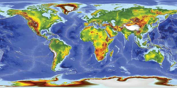
A variety of parameters may be inferred using the information from radar altimeter measurements. These include: time-varying sea-surface height (ocean topography), the lateral extent of sea ice and the altitude of large icebergs above sea level, as well as the topography of land and ice sheets, and even that of the sea floor. Topographical maps of the structure of the Arctic sea floor have not only revealed new mineral deposits, but they also provide new insights into how a large part of the ocean basin was formed about 100 million years ago.
Observations by current and future radar altimeters of trends in the ice masses of Earth are of principal importance in testing the predicted thinning of Arctic sea ice due to global warming. They also help to quantify the extent to which the Antarctic and Greenland ice sheets have contributed to the global rise in sea level. New-generation radar altimeters, such as RA-2 on Envisat, have provided useful information for the monitoring of inland waters (river and lake levels).
Satellite altimetry also provides information that is used in mapping sea-surface wind speeds and significant wave heights. Precision ocean altimetry applications for sea-level monitoring and ocean circulation studies require more accurate, independent measurements of the geoid, derived from the instruments described in the ‘gravity field’ category.
ESA’s CryoSat-2 mission provides an instrument for studying the topography of areas such as ice-sheet interiors and margins, and sea-ice with three-mode operation: conventional pulse-limited operation for the ice-sheet interiors (and oceans if desired); synthetic aperture operation for sea ice; and dual-channel interferometric synthetic aperture operation for ice-sheet margins.
The new generation of instruments will provide more frequent data coverage and faster access to observations for incorporation into ocean circulation and wave forecast models that are used to generate marine information products. New concepts of altimeter packages are being developed, such as the wide-swath altimeters, proposed by the SWOT mission, capable of providing an imaging capability.
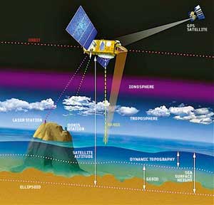
Radar altimeters measure the distance between the satellite and the sea surface. The distance between the satellite and the reference ellipsoid is derived by using the Doppler effect associated with signals emitted from marker points on Earth’s surface as the satellite orbits overhead. Variations in sea-surface height are caused by the combined effect of the geoid and ocean circulation (dynamic topography).
|
|