 |
|||||
 |
|
Managing natural disasters On average each year, natural disasters around the world leave 4 million people homeless, injure another 900,000 people and kill 128,000 people. These disasters also cause many billions of dollars of property damage. In 1991 and 1992 alone, property damage amounted to US$100 billion. A single event, Hurricane Andrew, caused US$25 billion of damage in the southern part of the United States of America in 1992. It has been estimated that, in the same year, the world economy lost more money (US$62 billion) from natural disasters in the less developed countries than it spent on development aid (US$60 billion). Natural disasters should be recognised as a major obstacle to sustainable development.
The natural or human-induced hazards which lead to these disasters with the potential to create loss to humans and to their welfare include: floods, typhoons, hurricanes and cyclones, earthquakes, tornadoes, volcanic eruptions, landslides, drought, and wildfires. A wide variation in the number and intensity of such natural hazards is normal and to be expected – but the events of the last few decades suggest that there may be an upward trend caused by human activities, in part due to increased vulnerability of human settlement locations. Many scientists believe that the recent upsurge of weather-related natural disasters is the product of increased global warming. There were three times as many great natural disasters in the 1990’s as in the 1960’s, while disaster costs increased more than nine-fold in the same period. The reason for the upward trend in loss of life and wealth is apparent; ninety per cent of disaster victims worldwide live in developing countries, where poverty and population pressures force growing numbers of poor people to live in harm's way - on flood plains, in earthquake-prone zones and on unstable hillsides. Disaster management information Natural disasters cannot be prevented, but their social and economic impacts can be reduced through effective disaster management programmes. Disaster management involves a series of information-intensive activities:
Hazards are characterised by information on geology, tectonics, seismicity, regimes of rivers and their water basins, amount & characteristics of fuel, local meteorological conditions, terrain and topography. Vulnerability derives very much from the location of assets such as urban centers and more precisely hospitals, schools, plants, road and utility networks, and the likely effect of a given disaster.
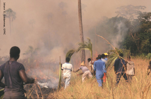
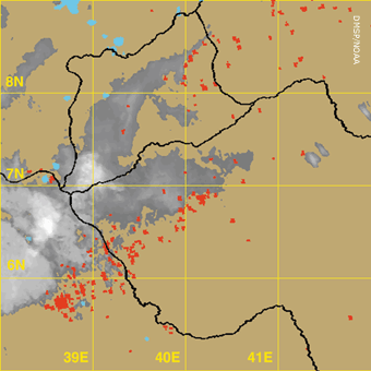
Meteorological forecasts are essential to prediction and warning of hurricanes, floods and fires. So far no reliable prediction system is available for earthquakes, although warnings may be issued for volcanoes and tsunamis. Evacuation plans and similar measures are triggered accordingly and their efficiency is conditioned heavily by available information on settlements, roads, etc. This is exemplified in areas which are frequently affected by disasters such as hurricanes (hundreds of thousands of citizens were evacuated during Hurricane Floyd’s visit to US coasts). An efficient response requires accurate and rapid knowledge of the location and intensity of damage. Information on roads, bridges, utility networks, critical infrastructure such as hospitals or airports is essential. The same type of information, coupled with knowledge of hazards, will help reconstruction planning, to assist avoidance of dangerous areas. Disaster reduction and risk management has moved rapidly up the policy agenda of affected governments and the international community. This trend has led to the adoption of the International Strategy for Disaster Reduction (ISDR) by governments to promote implementation of the recommendations emanating from the International Decade for Natural Disaster Reduction (IDNDR, 1990-1999). The aim of the ISDR is to mobilise Governments, UN-agencies, regional bodies, private sector and civil society to unite efforts in building resilient societies by developing a culture of prevention and preparedness. Amongst other actions, ISDR calls for action on the information required to: reduce human vulnerability; plan urban development strategies; monitor environmental risk factors and land use; and develop global, regional, national and local early warning systems. The role of Earth observation satellites Increasingly, data derived from Earth observation satellites is being used to contribute to the information requirements of different phases of disaster management programmes. Perhaps the best known of the Earth observing satellite missions, weather satellites, have been used for more than 40 years to support forecasting of intensive weather hazards such as tropical cyclones, severe storms, and flash flooding. Today, a number of countries operate weather satellites, coordinating their activities to benefit an international user community through organisations such as WMO. Derived products are produced routinely several times per day, many of them focused on particular hazard events. Tracking sequences of tropical cyclone images from geostationary satellites as well as storm intensities and atmospheric winds derived from these images provide information for forecasting landfall - where and when. Recent integration of experimental products, such as ocean surface winds from scatterometer instruments and moisture or rainfall from microwave instruments, has improved these forecasts.
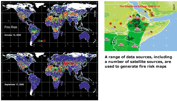
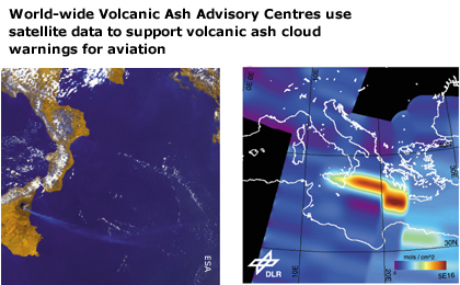
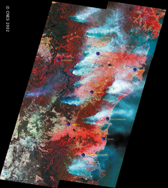
Forecasts and warnings for other severe storms utilise products also derived from sequences of images from geostationary satellites. Flash flood forecasts are improved with the integration of precipitation estimates derived from analysis of cloud imagery, and severe storm index sequences are utilised for warnings of severe storms such as tornadoes. By allowing society time to prepare for or avoid an impending hazard, such forecasting and early warning systems incorporating satellite data have dramatically reduced deaths, injuries, property damage and other economic losses. In recent years, Earth observation satellites have demonstrated their utility in providing data for a wide range of applications in disaster management. These include the mapping and monitoring of hydrological and seismic hazards, variables affecting climate and weather, land use, the extent of damage due to volcanic eruptions, oil spills, forest fires, the spread of desertification, and the forecasting of floods and droughts. Information from satellites is often combined with other relevant data in geographic information systems (GIS) in order to carry out risk assessment and help identify areas at risk. Some of these capabilities are shown in the table. |
||||||||||||||
|
||||||||||||||
|
Although Earth observation satellites have demonstrated their considerable potential in supporting a range of disaster management activities, the space agencies have recognised that further steps are necessary to persuade the disaster management community to assimilate these new technologies into their operations. Further, to meet the needs of such a diverse range of hazards and their often critical timescales for information, the space agencies decided to pool the satellite resources of different countries more effectively for the benefit of the international community. DMSG: The Disaster Management Support Group of CEOS was established in 1997, with the objective of supporting natural and technological disaster management on a worldwide basis by fostering improved utilisation of existing and planned EO satellite data. The DMSG serves as a forum to identify, and interact with, current and potential users of space-derived data as one of the tools to deal with disasters. DMSG includes specialist teams addressing different types of hazards and has developed substantial on-line resources. International Charter on Space and Major Disasters: The aim of this Charter, initiated by the French (CNES), European (ESA) and Canadian (CSA) space agencies is “to supply during periods of crisis, to States or communities whose population, activity or property are exposed to an imminent risk, or are already victims, of natural or technological disasters, data providing a basis for critical information for the anticipation and management of potential crises." ISRO (India), and NOAA (USA) also participate in the Charter. Since the Charter became operational on November 1st 2000, authorised civil defence organisations may enlist support from space by calling a telephone number, 24 hours a day, 365 days a year. Rescue and civil defence bodies of the country to which the participating agencies belong are registered authorised users. Civil protection authorities of other countries may also submit requests by contacting their sister organisations through existing co-operation mechanisms. http://www.disasterscharter.org Office of Outer Space Affairs, Committee on Peaceful Uses of Outer Space: The COPUOS Programme on Space Applications (PSA) works to improve the use of space science and technology for the economic and social development of all nations, in particular developing countries. Under the Programme, the Office conducts training courses, workshops, seminars and other activities on applications such as disaster management. The PSA, working closely with DMSG and the Charter, is focusing on defining and transferring technology-based solutions by holding Regional Workshops on the Use of Space Technology for Disaster Management. Future challenges There are a number of obstacles to the increased use of Earth observation satellite data in disaster management applications – both institutional and technical. Institutionally, it is recognised that there must be greater cooperation between satellite-operating agencies, between these agencies and the commercial sector, and between all data providers and the disaster management community. This cooperation is essential if we are to achieve the scale, frequency of measurements, and speed of response, which are required to face diverse and time-critical disasters. There
is a general reluctance among the disaster management community
to assimilate new technologies and information quickly, due to concern
for introducing new, unproven technology into operational programs,
and due to the lack of products and services tailored to their needs.
In order to promote wider acceptance and use of space systems by
disaster management users, the space and services communities must
create the appropriate Technically, we can expect to see future efforts aiming at providing satellite-derived information more rapidly and at higher spatial resolutions, consistent with the needs of many disaster management applications. A number of new capabilities can also be expected, including:
|
||||||||||||||
|
||||||||||||||
|
||||||||||||||