 |
|||||
|
The importance of Earth observations
This information will be required on all scales – from local to global. We can anticipate that it might be used by intergovernmental bodies for decision-making and global governance to ensure sustainability, and also more locally as countries, regions, and industries compete for larger shares of smaller reserves of natural resources in order to support their growing populations and economic ambitions. Such information takes many forms, spanning data on population, demographics, economics, and environmental indicators. Observations of planet Earth itself, of man’s environment, might be regarded as the most important of all, as the context for all decisions. Earth observing systems help to provide data in support of a wide range of information needs, on Earth parameters which are central to:
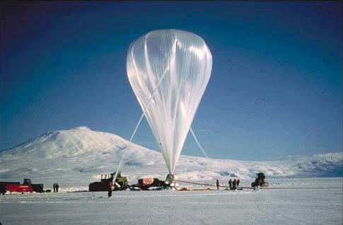
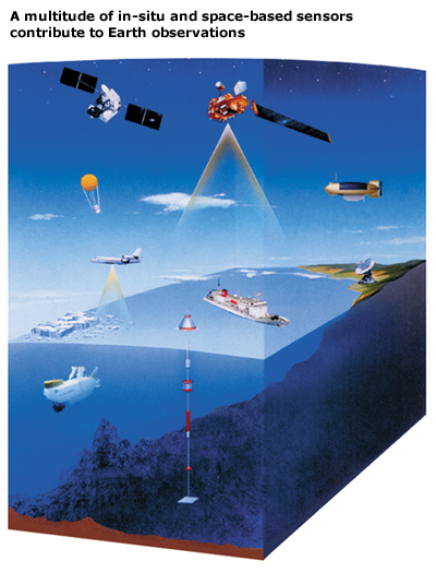
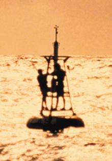
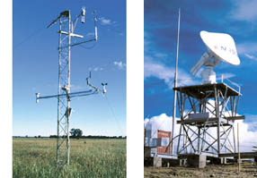
The status of Earth observing programmes Earth observing systems encompass a broad range of different networks of satellite-borne and Earth-based sensors, including ocean buoys, weather stations and atmospheric radiosondes – providing important parameters relating to land, ocean, and atmospheric processes. It has long been recognised that the range of observations, many of which are global, needed to understand and monitor Earth system processes and to assess the impact of human activities cannot be satisfied by a single program, agency, or country. The main Earth observing networks are therefore typically international collaborative programmes by nature.
World Weather Watch The best known of these networks may be the World Weather Watch (WWW) of the World Meteorological Organization (WMO). The WWW is a unique achievement in international cooperation, providing a truly world-wide operational system to which virtually every country in the world contributes, every day of every year, for the common benefit of mankind. The Global Observing System (GOS) of the WWW - which includes around 10,000 stations on land providing observations near the Earth’s surface, at least every three hours, of meteorological parameters such as atmospheric pressure, wind speed and direction, air temperature and relative humidity - ensures that every country has all the information available to generate weather analyses, forecasts and warnings on a day-to-day basis. The most obvious benefits of the GOS are the safeguarding of life and property through the forecasting, detection and warning of severe weather phenomena such as local storms, tornadoes, and tropical cyclones. GOS provides observational data for agricultural management, aviation safety, meteorology and climatology, including the study of global change. These observations also provide an international database of upper air observations for research purposes. 22 Global Atmosphere Watch (GAW) stations world-wide supplement these observations with information on ozone, other greenhouse gases, solar radiation, UV, and other atmospheric and meteorological parameters. The Global Observing Systems Within the last decade, the Global Observing System of the World Weather Watch has been complemented by the Global Ocean Observing System (GOOS) and the Global Terrestrial Observing System (GTOS) to produce a set of Global Observing Systems integrating in-situ and remotely sensed data from a range of international, regional and national observing systems and networks, with each focusing on a major component of the Earth system. The Global Climate Observing System (GCOS) has also been planned and initiated to integrate the observing needs for climate purposes. GOOS: GOOS is a permanent global system for observations, modelling and analysis of marine and ocean variables to support operational ocean services worldwide. GOOS will provide accurate descriptions of the present state of the oceans, including living resources; continuous forecasts of the future conditions of the sea; and the basis for forecasts of climate change. GOOS is capitalising on existing ocean observing systems, such as:
There are numerous other contributors to GOOS, including: voluntary observing ships providing measurements of upper ocean and meteorological parameters; the Global Temperature and Salinity Profile Programme; and the Global Coral Reef Monitoring Network. GTOS: GTOS aims to provide the scientific and policy making community with access to the data necessary to manage the change in the capacity of terrestrial ecosystems to support sustainable development. To achieve this GTOS is working towards the establishment of a “system of networks", formed by linking existing terrestrial monitoring sites and networks as well as planned satellite remote sensing systems. Thematic networks have been established for ecology, glaciers, and permafrost, and a hydrology network is in progress. Since the sustainable development of forest resources is regarded as one of the most pressing environmental issues of our time, GTOS has established a panel on Global Observations of Forest Cover (GOFC) which aims to provide regional and global datasets containing information on location of different types of forests; major changes in forests resulting from logging, agricultural conversion, fire, and other environmental stresses. GTOS, in collaboration with a number of partners, has also developed the Terrestrial Carbon Observations (TCO) initiative which responds to the need by the policy and scientific communities for improved knowledge of the role of the terrestrial carbon sources and sinks. It aims to provide information on the spatial and temporal distribution of carbon sources and sinks in the terrestrial biosphere using data obtained through systematic ground and satellite-based observations. GCOS: GCOS was established in 1992 to ensure that the observations and information needed to address climate-related issues are obtained and made available to all potential users. It is co-sponsored by WMO, the IOC, the United Nations Environment Programme (UNEP) and the International Council for Science (ICSU). GCOS is intended to be a long-term, user-driven operational system capable of providing the comprehensive observations required for monitoring the climate system, for detecting and attributing climate change, for assessing the impacts of climate variability and change, and for supporting research toward improved understanding, modelling and prediction of the climate system. It addresses the total climate system including physical, chemical and biological properties, and atmospheric, oceanic, hydrologic, cryospheric and terrestrial processes. GCOS does not itself directly make observations nor generate data products. It stimulates, encourages, coordinates and otherwise facilitates the taking of the needed observations by national or international organisations in support of their own requirements as well as of common goals. It provides an operational framework for integrating, and enhancing as needed, observational systems of participating countries and organisations into a comprehensive system focussed on the requirements for climate issues. GCOS
builds upon, and works in partnership with, other existing and developing
observing systems such as the Global Ocean Observing System, the
Global Terrestrial Observing System, and the Global Observing System
and Global Atmospheric Watch IGOS-P: The Integrated Global Observing Strategy Partnership Earth observations from satellite have revolutionized human perspectives and understanding of the planet and are highly complementary to those collected on or near the Earth’s surface by in-situ systems - such as ocean buoys or weather stations. In-situ measurements may be necessary for some high accuracy local observations, for the calibration of observations made by satellite and for models of the Earth system. Satellites are often necessary for the provision of synoptic, wide-area information required to put in-situ measurements in the global context required for the observation of many environmental and climatic phenomena. In order to facilitate the necessary harmonisation and achieve maximum cost-effectiveness for the total set of space-based and in-situ observations the IGOS Partnership was established in June 1998 by a formal exchange of letters among the 13 founding Partners for the definition, development and implementation of an Integrated Global Observing Strategy (IGOS). IGOS brings together the major Earth and space-based systems for global environmental observations of the atmosphere, oceans and land in a strategic planning process. The IGOS Partners recognise that many of their respective observing systems are in need of improvements. Some lack the necessary long-term continuity, and all require strengthened links between the space-based and Earth-based components, as well as between the observing programmes and the processes of scientific and environmental policymaking which define the information priorities. Further
information on IGOS-P is presented in part annex B.
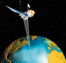
Satellite Earth observations Since the first TV images of the Earth from space were transmitted by the TIROS-1 satellite back in 1960, mankind has recognised the benefits of this unique and global perspective of our home planet. There are currently over 60 Earth observation satellite missions operating, and around 90 more missions, carrying over 300 instruments, planned for operation during the next 15 years or so by the world’s civil space agencies. An increasing number of commercial Earth observation satellites, which are funded, launched, and operated by industry, are also emerging to address important spatial information markets. Space-based, remote sensing observations of the atmosphere-ocean-land system have evolved substantially since the first operational weather satellite systems were launched. Over the last decade Earth observation satellites have proven their capabilities to accurately monitor nearly all aspects of the total Earth system on a global basis; a capability unmatched by ground-based systems that are limited to land areas and cover only about 30% of the planetary surface. Currently, satellite systems monitor the evolution and impact of the El Niño, weather phenomena, natural hazards, and extreme events such as floods and droughts, vegetation cycles, the ozone hole, solar fluctuations, changes in snow cover, sea ice and ice sheets, ocean surface temperatures and biological activity, coastal zones and algae blooms, deforestation, forest fires, urban development, volcanic activity, tectonic plate motions, and others. These various observations are used extensively in real-time decision-making and the strategic planning and management of industrial, economic, and natural resources. The proliferation of Earth observation satellites reflects their unique abilities and benefits, such as:
Present-day applications of satellite data are widespread and cover research, operational and commercial activities. On a global scale, space-based systems make a considerable contribution to the collection of data required for climate change research, in providing high-quality, consistent, global datasets over long time periods for use in understanding the climate system, detection of potential anthropogenic change, validating climate models, and predicting future change. Satellites are capable of obtaining global spatial coverage, particularly over the vast expanses of the oceans, sparsely populated land areas (eg deserts, mountains, forests, and polar regions), and the mid and upper troposphere and stratosphere. Satellites provide unique measurements of solar output, the Earth’s radiation budget, vegetation cover, ocean biomass productivity, atmospheric ozone, stratospheric water vapor and aerosols, greenhouse gas distributions, sea level and ocean interior, ocean surface conditions and winds, weather, and tropical precipitation, among others.
CEOS is recognised as the most important framework for coordination across all spaceborne Earth observation missions. CEOS also plays an important role within the IGOS Partnership to ensure that future space-based observing systems and Earth-based observing systems will be suitably harmonised to address the most critical requirements. The case studies presented in Part II highlight the importance of Earth observations, in particular satellite observations, in providing essential information to address some of the key issues facing mankind at the start of the 21st century. |
||||||||||||||
|
||||||||||||||