Part of the improvement in human life expectancy achieved during the last century may be attributed to our improved understanding of environmental influences on our health and well-being. Contributing factors include improved sanitation, cleaner water and air, and more effective understanding of (and control of) the sources and means of transmission of disease.
The GEOSS Implementation Plan (described in Section 2) outlines a vision for Earth observing systems to make a significant contribution to continued improvements in human health in both developed and developing countries, through implementation of a system of remote sensing and in-situ observations integrated through assimilation and modelling tools with census data on health. The outputs would identify environmental conditions, health hazards, and at risk populations, and establish epidemiological associations between measurable environmental parameters, chronic and infectious diseases, and health conditions.
Environmental datasets can be powerful tools in support of research, epidemiology, health care planning and delivery, and public health alerts. For example, by linking weather and air quality data, air quality forecasts can help protect those at risk from air pollution episodes – such as asthmatics and the elderly. And by connecting the environmental requirements of pathogens with weather and other data, it is possible to predict outbreaks of infectious diseases such as malaria, and to reduce the impact and/or severity of the outbreak. Remotely sensed land-use data can support monitoring of water quality and allow communities to better target in-situ water quality monitoring and remedial efforts. Better UV-B measurements and warning systems will help contribute to reductions in the incidence of skin cancer and cataracts around the world.
Such observations, delivered in a sustained and timely fashion, can bring a focus to predictive and preventative aspects of health, particularly with respect to environmental hazards such as pollutants. At a global level, the availability of remotely sensed and in-situ environmental data offers promise of powerful new tools for the discovery of early indicators of health hazards – alerting the community and providing time for hazard avoidance or disease mitigation.
The role of Earth observation satellites
Earth observation satellite data has the potential to supply information on a range of important health-related parameters. These measurements are of particular value: where alternative in-situ measurement networks are not available in support of public health programmes (notably in many developing countries), and for wide-area monitoring as the basis for forecasting and alerting services.
Current health-related applications of satellite data include:
- detection of environmental factors associated with disease-vector habitats and human transmission risk;
- monitoring of air and water quality measures.
Examples of these applications are discussed below.
.jpg)
.jpg)
ESA’s HUMAN project supplies satellite data to Medecins Sans Frontieres (MSF) in Nicaragua. Aid workers are using imagery of crowded slums to analyse infections by Chagas disease on a house by house basis and to implement effective control and monitoring programmes on the ground.
Disease Early Warning Systems
Since the 1970s, researchers have been studying the potential of Earth observation satellite data in geographic information systems (GIS) for disease early warning primarily in ‘landscape epidemiology’ applications.
Landscape epidemiology involves the identification of geographical areas where disease is transmitted. By knowing the vegetation and geologic conditions necessary for the maintenance of specific pathogens in nature, one can use the landscape to identify the spatial and temporal distribution of disease risk. Key environmental elements, including elevation, temperature, rainfall, and humidity, can influence the presence, development, activity, and longevity of pathogens, vectors, reservoirs of infection, and their interactions with humans.
Most of these studies have focused on the derivation of vegetation cover, landscape structure, and water bodies. These factors are important because the distribution of vegetation types integrates the combined impact of rainfall, temperature, humidity, topographic effects, soil, water availability, and human activities. Nearly all vector-borne diseases are linked to the vegetated environment during some aspect of their transmission cycle.
NASA’s Center for Health Applications of Aerospace Related Technologies (CHAART) has undertaken a review documenting research undertaken in public health projects involving the world’s major diseases that are thought to have environmental components that can be monitored using remotely sensed data. These include: Chagas’ disease, cholera, dengue fever, filariasis, hantavirus pulmonary syndrome, leishmaniasis, lyme disease, malaria, river blindness, plague, Rift Valley fever, schistosomiasis, trypanosomiasis (sleeping sickness), and yellow fever. Projects to map the vectors of these diseases by satellite have been trialled in a wide range of countries, including: Belize, Benin, Gambia, Kenya, Mexico, Senegal, and USA.
It is not only landscape parameters that are of value in this context. Links have been established between outbreaks of cholera in India and Bangladesh and oceanic conditions in the Bay of Bengal – including anomalies in sea surface height, temperature, and concentrations of chlorophyll and phytoplankton. Data from AVHRR, SeaWiFS, and Topex-Poseidon (amongst other sources) have been used in support of these assessments.
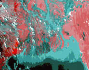
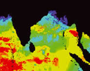
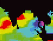
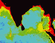
| Datasets used to model the temporal patterns of cholera outbreaks in Bangladesh. |
 |
 |
| A AVHRR image of the mouth of the Ganges and the Bay of Bengal. Vegetation is shown in shades of red and water in shades of blue. |
B Sea surface temperature data, derived from AVHRR |
 |
 |
| C Sea surface height data, derived from TOPEX-Poseidon |
D SeaWiFS image showing chlorophyll concentrations |
Air quality monitoring
Global monitoring of the atmosphere is one of the most significant contributions of environmental satellites to the study of the Earth’s climate and its changes. The capabilities of the latest generation of atmospheric monitoring sensors are also enabling satellites to provide measurements at a finer (local) spatial scale, and at lower levels of the atmosphere, down to ground level – which is most relevant to public health alerts.
A number of sensors – including MOPITT (providing measurements of carbon monoxide and methane in the troposphere), TES (carbon monoxide, methane, HNO3), and GOMOS, MIPAS, and SCIAMACHY (on the ENVISAT spacecraft) are providing new and powerful streams of information on air quality and composition of potential benefit to public health. Environmental protection and public health agencies are studying how to incorporate such information into their operations and warning systems – through projects such as IDEA (Infusing Satellite Data into Environmental Air Quality Applications), which combines the assets of NASA and the US Environmental Protection Agency (EPA) with NOAA’s weather information in order to improve the EPA’s decision-making tools with satellite observations for better air quality forecasts.
.jpg)
.jpg)
Carbon Monoxide pollution in North America measured by MOPITT (CSA) and nitrogen dioxide pollution in Europe measured by SCIAMACHY (ESA)
In Europe, ESA is participating in the establishment of the GMES (Global Monitoring for Environment and Security) Atmosphere Service – which will provide information on the ozone layer, UV-exposure on the ground, air pollution and climate change. These services are directed at the needs for information on environment and climate by public authorities, governmental agencies, the general public, and industry.
Respiratory illnesses are on the rise across the developed world. Tainted air around urban centres – originating from power generation, industry or traffic – is a well-known problem, but difficult to solve. Space-based instruments trace otherwise invisible plumes of waste chemicals as they move through the air, providing maps of their concentrations in three dimensions. Such data can be used to provide daily forecasts of meteorological fields and air pollution – valuable additions to the monitoring undertaken by fixed-location stations on the ground.
| Malaria Early Warning Systems |
|
The ‘Roll-Back Malaria’ programme of the World Health Organization (WHO) has implemented a number of Malaria Early Warning Systems (MEWS) intended to facilitate timely responses that will prevent and contain malaria epidemics. MEWS comprise forecasting, early warning, and early detection. Forecasting usually refers to seasonal climate forecasts; early warning refers to the monitoring of meteorological conditions such as rainfall and temperature; and early detection is based on routine clinical surveillance.
WHO has supported development of simple tools to monitor epidemic risks in marginal transmission areas based on anomalies in rainfall and temperature identified from satellite observations. Rainfall is one of the major factors influencing malaria transmission in semi-arid and desert-fringe areas of Africa. Epidemics may occur after excessive rains, usually with a lag time of several weeks during which mosquito vector populations and malaria infections gradually increase. Epidemics following drought and poor food security conditions can be especially severe.
|
Risks are displayed on maps which are updated every 10 days and can be freely accessed via the WHO/RBM web site. MEWS are generally performing well in southern Africa, and studies have started in Ethiopia, Kenya, Uganda, the United Republic of Tanzania, and Sudan. Decision-tree models are being constructed and validated. Work remains to be done to better involve staff from meteorological services in joint ventures with ministries of health to regularly compile and evaluate data and disseminate warnings to communities. |
.jpg) |
Number of inpatient malaria cases in selected hospitals in Namibia, compared measurements of 'cold cloud duration' - a satellite-derived proxy for rainfall |
.jpg) |
|
Future challenges
Many applications are at a research or pre-operational stage. Improved utilisation of satellite data for the benefit of human health will require a combination of:
- making better use of the capabilities that are currently available, including improved linkages between data providers and healthcare communities; capacity building in developing countries to ensure the means and understanding for use of the data; better integration of satellite data with existing datasets to exploit its full potential; and
- translation of the new and planned measurement capabilities from scientific prospects into operational services, including through adequate modelling and analysis capabilities in order to derive the essential information; adequate spatial and temporal coverage will continue to be a challenge.
BACK TO TOP |