– EO data have been central to the formulation of the authoritative scientific advice that the current climate negotiations are responding to.
– EO data will be essential in assessing the cost- effectiveness over time of any policy measures agreed, based on changes in the key environmental indicators. Reliable space-based observations can provide the authoritative records of climate change needed to empower governments and the private sector to make informed decisions.
– Of the 50 ECVs defined by the Global Climate Observing System (GCOS), more than half have a major contribution from satellite observations.
– Without the insights offered by satellite EO, there will be insufficient evidence with which to inform our decision-makers on environmental policies, including those aimed at mitigation and adaptation to climate change.
Improved understanding of the Earth system – its weather, climate, oceans, land, geology, natural resources, ecosystems and natural and human-induced hazards – is essential if we are to better predict, adapt and mitigate the expected global changes and their impacts on human civilisation. EO data and derived information are essential inputs in the development of this understanding.
Scientists concerned with climate variability and change have, from the very beginning, recognised the importance of observations to our understanding of the atmosphere and the application of atmospheric science to human affairs. Without accurate, high-quality observations on all time and space scales, climate science and services could make only limited progress.
Systematic international coordination of weather and climate observations began around the middle of the 19th century and advanced rapidly in the 1960s and 1970s as the advent of digital computers and EO satellites inspired the establishment of the operational World Weather Watch and the Global Atmospheric Research Programme.
The great step forward came in the 1980s with the realisation that understanding and predicting climate would require the involvement of a much wider set of scientific communities and comprehensive observation of the entire atmosphere-ocean-land climate system. This inspired the vision for an integrated Global Climate Observing System (GCOS), which was formally established in 1992 as an international, interagency interdisciplinary framework for meeting the full range of national and international needs for climate observations.
Non-satellite observational systems contributing to the GCOS include atmospheric, oceanic and terrestrial components.
The atmospheric component includes networks for measurement of temperature, humidity and winds aloft, including the WMO Global Atmosphere Watch (GAW) global baseline ozone networks and the WMO GAW Global Atmospheric CO and CH Monitoring Networks.
The surface ocean network provides information about the patterns of ocean surface temperature, pressure, winds, salinity, sea level, waves and sea ice that are important both to the global climate and its regional distribution. Its main systems are: the global networks of tide gauges; moored and drifting buoys; and voluntary observing ships. The sub-surface ocean network provides critical information on ocean climate variability and change and is also based on buoy and ship measurements.
The conventional climate observing system in the terrestrial domain remains the least well-developed component of the global system. Current networks monitor river discharge, glacier hydrology, lake level/area, permafrost, on-going space-based and in-situ observations of forests and other vegetation cover and global and regional change in coastal areas.
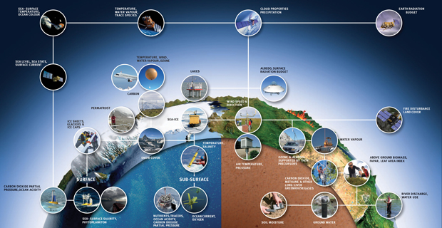
Figure 1: Some of the multitude of observing systems and the observations that contribute to the GCOS
How Satellites Help
While the conventional observing networks provide critical climate measurements at a number of points around the globe and undertake some measurements that are as yet not technically feasible from space at required accuracies, (eg surface air temperature), they have limitations when it comes to observing global climate change. For the most part, the atmospheric observations are limited to the land areas of the Earth and are highly concentrated in the major population centres of the developed countries. Ocean areas – 70% of the globe – are largely under-sampled in terms of atmospheric measurements. And there are also large gaps in the coverage of surface and sub-surface ocean measurements. In-situ terrestrial observation networks also have large gaps. Constructing a reliable picture of global climate change from an observing system that has such large voids is an impossible task.
Satellites and complementary in-situ networks provide the global coverage needed to observe and document worldwide climate change. Space-based remote sensing observations of the atmosphere-ocean-land system have evolved substantially since the first weather satellite systems were launched 55 years ago. EO satellites have proved their capabilities to accurately monitor multiple aspects of the total Earth system on a global basis.
Currently, satellite systems monitor the evolution and impact of the El Niño (including a strong occurrence in 2015), weather phenomena, natural droughts, vegetation cycles, the ozone hole, solar fluctuations, changes in snow cover, sea ice and ice sheets, ocean surface temperatures and biological activity, coastal zones and algal blooms, deforestation, forest fires, urban development, volcanic activity, tectonic plate motions and more.
EO satellites are being developed and launched in support of climate information needs and their proliferation reflects their unique abilities and benefits:
– wide area observation capability: a single instrument on a polar orbiting satellite can observe the entire Earth on a daily basis, while instruments on geostationary satellites continuously monitor the diurnal cycle of the disk of Earth below them; together the polar and geostationary environmental satellites maintain a constant watch on the entire globe;
– non-intrusive observations allowing collection of data to take place without compromising national sovereignty;
– uniformity that enables the same sensor to be used at many different places in the world;
– rapid measurement capability, allowing sensors to be targeted at any point on Earth, including remote and inhospitable areas, enabling monitoring of deforestation in vast tropical forests and tracking ice loss in the polar regions year-round;
– continuity, with single sensors or series of sensors providing long time series of data suitable for climate studies.
More than 40 nations are identified as having invested in EO satellites, amounting to government investment of approximately US$7-8 billion per annum, with further and increasing investment coming from the commercial sector and through public-private partnerships. These investments have been made with a view to numerous and diverse applications of the space-based infrastructure and the observing capabilities of the hundreds of satellites involved, including studies of climate, environmental issues, agriculture, meteorology and natural disasters. A large proportion of the EO satellites in operation or planning are dedicated to climate and meteorology observations.
Some of the unique contributions of EO satellites to the development of climate information are presented in Part III of this document. More detailed explanation of the different instrument types and climate measurements that they provide can be found in the online version of the EO Handbook: www.eohandbook.com
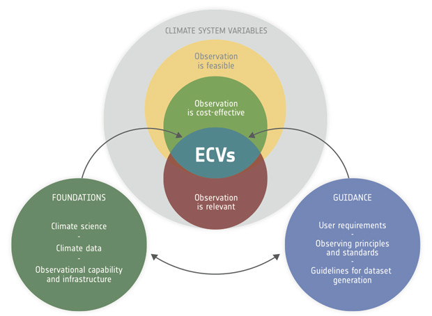
Figure 2: Schematic of the ECV concept: knowing existing climate- relevant observing capabilities, climate datasets and the level of scientific understanding of the climate system are the foundations (lower-left circle) necessary for selecting the ECVs from a pool of climate system variables. In addition, guidance is needed to make practical use of the ECVs (lower-right circle): user requirements capture the data quality needs of science, services
and policy; climate-specific principles guide the operation of observing systems and infrastructure; and guidelines facilitate the transparent generation of ECV data records. The latter address the availability of metadata, provisions for data curation and distribution and the need for quality assessment and peer review
Credit: (Bojinski et al., 2014)
The Essential Climate Variables
Observations are fundamental to advancing scientific understanding of climate and delivering the vetted, timely and purposeful climate information needed to support decision-making in many sectors.
In the 1990s, gaps in knowledge of climate and declining core observational networks in many countries led to calls for systematic observation of a limited set of critical variables. To provide guidance, GCOS developed the concept of “essential climate variables” (ECVs) (Bojinski et al, 2014). An ECV is a physical, chemical or biological variable or a group of linked variables that critically contributes to the characterisation of Earth’s climate. ECV datasets provide the empirical evidence needed to understand and predict the evolution of climate, to guide mitigation and adaptation measures, to assess risks and enable attribution of climatic events to underlying causes and to underpin climate services.
ECVs are not a select group of stand-alone variables. Rather they are part of a wider concept and are identified based on the following criteria:
– Relevance: the variable is critical for characterising the climate system and its changes;
– Feasibility: observing or deriving the variable on a global scale is technically feasible using proven, scientifically understood methods;
− Cost effectiveness: generating and archiving data on the variable is affordable, mainly relying on coordinated observing systems using proven technology, taking advantage where possible of historical datasets.
Science and policy circles have widely endorsed the ECV concept. The parties to the UNFCCC acknowledged the need to act upon the plans for implementation. Guidelines for reporting on national programmes contributing to global climate observation are structured along the ECVs. In its planning of global observation for weather, water and climate applications, WMO addresses the ECVs and recognizes GCOS assessment and planning documents as statements of guidance.
Space agencies have responded strongly to the concept, through the Committee on Earth Observation Satellites (see Section 4) and through the broadly developed Architecture for Climate Monitoring from Space (see Section 5).
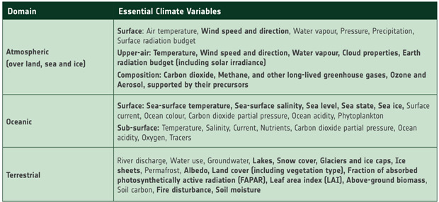
Of the 50 ECVs identified by GCOS, more than half have a major contribution from EO satellite measurements, with several exclusively derived from EO satellite measurements.
Some of the unique contributions from EO satellites are explained in Part III of this document.
Figure 3: The ECVs – satellite observations make a major contribution to the ECVs shown in bold